San Miguel geodata
San Miguel (Chiapas) is a populated place; located in Mexico in America/Mexico_City (GMT-6) time zone. With population of 1,373 people, there are 6322 cities with bigger population in this country. Compared to other cities in Mexico, 84.6% of cities are located further ↑North; 95.3% of cities are located further ←West and 76.2% of cities have higher elevation than San Miguel. Note1


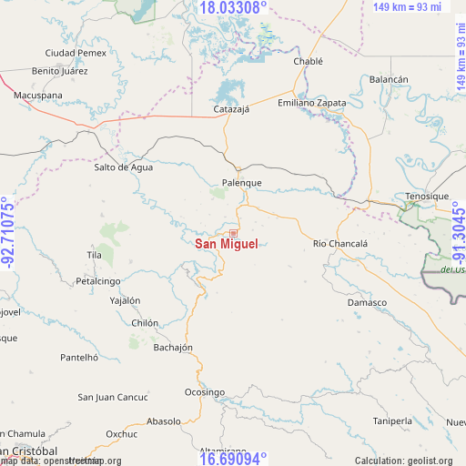
San Miguel GPS coordinates[2]
17° 21' 47.664" North, 92° 0' 27.432" West
| Map corner | latitude | longitude |
|---|---|---|
| Upper-left | 18.03308°, | -92.71075° |
| Center: | 17.36324°, | -92.00762° |
| Lower-right: | 16.69094°, | -91.3045° |
| Map W x H: | 149.2×149.2 km | = 92.7×92.7mi |
| max Lat: | 32.7° ⇑84.6% North |
| San Miguel: | 17.36324° |
| min Lat: | ⇓15.4% South 14.53588° |
| min Long | San Miguel | max Long |
| -117.105° | -92.00762° | -86.73105° |
| W 95.3%⇐ | ⇒4.7% E |
Elevation
Elevation of San Miguel is 178 m = 584 ft, and this is 1075.7 m = 3529 ft below average elevation for this country.
| Max E: |
3497 m = 11473 ft | 76.2% |
| Avg. | 1253.7 m = 4113 ft | |
| San Miguel | 178 m = 584 ft | |
Min E: |
-1 m = -3 ft | 23.8% |
See also: Mexico elevation on elevation.city.
Geographical zone
San Miguel is located in North Torrid zone (between Equator and Tropic of Cancer). Distance of this Northern Tropic circle is 675.3 km =419.6 mi to North.| Distance of | km | miles | from San Miguel |
|---|---|---|---|
| North Pole | 8076.5 | 5018.5 | to North |
| Arctic Circle | 5470.6 | 3399.3 | to North |
| Tropic Cancer | 675.3 | 419.6 | to North |
| Equator | 1930.6 | 1199.6 | to South |


Nearby cities:
15 places around San Miguel: (largest is in red/bold)
• Adolfo Ruiz Cortínes
3.7 km =2.3 mi,  45°
45°
• Belisario Domínguez
5.4 km =3.4 mi,  28°
28°
• Chivaltic Nuevo
9.7 km =6 mi,  308°
308°
• El Bascán (Lucha Bascán)
9.2 km =5.7 mi,  285°
285°
• Estrella de Belén
5.8 km =3.6 mi,  62°
62°
• Francisco I. Madero
4.8 km =3 mi,  272°
272°
• Ignacio Zaragoza
5.9 km =3.7 mi,  333°
333°
• Jerusalén
5.7 km =3.5 mi,  275°
275°
• La Aurora
8.1 km =5 mi, 64°
• Nazareth
6.3 km =3.9 mi,  81°
81°
• Profresor Roberto Barrios
9.6 km =6 mi,  115°
115°
• Puyipa
7.5 km =4.7 mi,  103°
103°
• Río Tulija
8.5 km =5.3 mi,  209°
209°
• Santa María
7.4 km =4.6 mi,  260°
260°
• Vicente Guerrero
7.5 km =4.7 mi,  217°
217°
Sources, notices
• [Note1] Compared only with cities in Mexico existing in our database
• [Src1] Map data: © OpenStreetMap contributors (CC-BY-SA)
• [Src2] Other city data from geonames.org with taken over terms of usage.
• [Src3] Geographical zone / Annual Mean Temperature by Robert A. Rohde @ Wikipedia
