Nazareth geodata
Nazareth (Chiapas) is a populated place; located in Mexico in America/Mexico_City (GMT-6) time zone. With population of 568 people, there are 15043 cities with bigger population in this country. Compared to other cities in Mexico, 84.5% of cities are located further ↑North; 95.5% of cities are located further ←West and 72% of cities have higher elevation than Nazareth. Note1


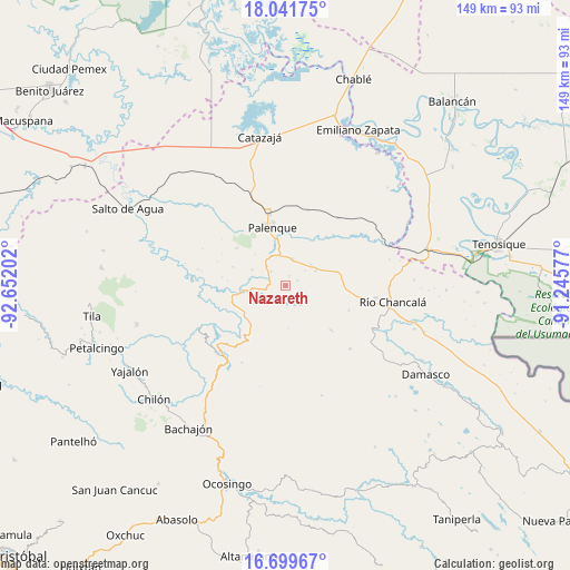
Nazareth GPS coordinates[2]
17° 22' 18.984" North, 91° 56' 56.004" West
| Map corner | latitude | longitude |
|---|---|---|
| Upper-left | 18.04175°, | -92.65202° |
| Center: | 17.37194°, | -91.94889° |
| Lower-right: | 16.69967°, | -91.24577° |
| Map W x H: | 149.2×149.2 km | = 92.7×92.7mi |
| max Lat: | 32.7° ⇑84.5% North |
| Nazareth: | 17.37194° |
| min Lat: | ⇓15.5% South 14.53588° |
| min Long | Nazareth | max Long |
| -117.105° | -91.94889° | -86.73105° |
| W 95.5%⇐ | ⇒4.5% E |
Elevation
Elevation of Nazareth is 328 m = 1076 ft, and this is 925.7 m = 3037 ft below average elevation for this country.
| Max E: |
3497 m = 11473 ft | 72% |
| Avg. | 1253.7 m = 4113 ft | |
| Nazareth | 328 m = 1076 ft | |
Min E: |
-1 m = -3 ft | 28% |
See also: Mexico elevation on elevation.city.
Geographical zone
Nazareth is located in North Torrid zone (between Equator and Tropic of Cancer). Distance of this Northern Tropic circle is 674.3 km =419 mi to North.| Distance of | km | miles | from Nazareth |
|---|---|---|---|
| North Pole | 8075.5 | 5017.9 | to North |
| Arctic Circle | 5469.6 | 3398.7 | to North |
| Tropic Cancer | 674.3 | 419 | to North |
| Equator | 1931.6 | 1200.2 | to South |


Nearby cities:
15 places around Nazareth: (largest is in red/bold)
• Adolfo Ruiz Cortínes
3.9 km =2.4 mi,  294°
294°
• Arimatea
8.4 km =5.2 mi,  113°
113°
• Belisario Domínguez
5.3 km =3.3 mi,  315°
315°
• Doctor Samuel León Brindis
7.3 km =4.5 mi,  14°
14°
• Egipto
12.4 km =7.7 mi,  191°
191°
• Estrella de Belén
2 km =1.2 mi,  328°
328°
• Francisco I. Madero
11.1 km =6.9 mi,  266°
266°
• Ignacio Zaragoza
9.8 km =6.1 mi,  296°
296°
• Jerusalén
11.9 km =7.4 mi, 267°
• La Aurora
2.7 km =1.7 mi,  24°
24°
• Nueva Galilea
11.8 km =7.3 mi,  120°
120°
• Nuevo Sonora
8.7 km =5.4 mi,  49°
49°
• Profresor Roberto Barrios
5.7 km =3.5 mi,  155°
155°
• Puyipa
3 km =1.9 mi, 159°
• San Miguel
6.3 km =3.9 mi,  261°
261°
Sources, notices
• [Note1] Compared only with cities in Mexico existing in our database
• [Src1] Map data: © OpenStreetMap contributors (CC-BY-SA)
• [Src2] Other city data from geonames.org with taken over terms of usage.
• [Src3] Geographical zone / Annual Mean Temperature by Robert A. Rohde @ Wikipedia
