Arroyo de la Luna geodata
Arroyo de la Luna (Guanajuato) is a populated place; located in Mexico in America/Mexico_City (GMT-6) time zone. With population of 506 people, there are 16626 cities with bigger population in this country. Compared to other cities in Mexico, 57.4% of cities are located further ↓South; 70.3% of cities are located further →East and 70.6% of cities have lower elevation than Arroyo de la Luna. Note1


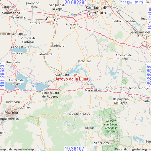
Arroyo de la Luna GPS coordinates[2]
20° 1' 23.052" North, 100° 35' 35.16" West
| Map corner | latitude | longitude |
|---|---|---|
| Upper-left | 20.68229°, | -101.29623° |
| Center: | 20.02307°, | -100.5931° |
| Lower-right: | 19.36107°, | -99.88998° |
| Map W x H: | 146.9×146.9 km | = 91.3×91.3mi |
| max Lat: | 32.7° ⇑42.6% North |
| Arroyo de la Luna: | 20.02307° |
| min Lat: | ⇓57.4% South 14.53588° |
| min Long | Arroyo de la Lu | max Long |
| -117.105° | -100.5931° | -86.73105° |
| W 29.7%⇐ | ⇒70.3% E |
Elevation
Elevation of Arroyo de la Luna is 1937 m = 6355 ft, and this is 683.3 m = 2242 ft above average elevation for this country.
| Max E: |
3497 m = 11473 ft | 29.4% |
| Arroyo de la Luna | 1937 m 6355 ft | |
| Avg. | 1253.7 m = 4113 ft | |
Min E: |
-1 m = -3 ft | 70.6% |
See also: Mexico elevation on elevation.city.
Geographical zone
Arroyo de la Luna is located in North Torrid zone (between Equator and Tropic of Cancer). Distance of this Northern Tropic circle is 379.6 km =235.9 mi to North.| Distance of | km | miles | from Arroyo de la Luna |
|---|---|---|---|
| North Pole | 7780.7 | 4834.7 | to North |
| Arctic Circle | 5174.8 | 3215.5 | to North |
| Tropic Cancer | 379.6 | 235.9 | to North |
| Equator | 2226.4 | 1383.4 | to South |


Nearby cities:
15 places around Arroyo de la Luna: (largest is in red/bold)
• Agua Caliente
8.8 km =5.5 mi,  282°
282°
• Arroyo Colorado
3.4 km =2.1 mi,  242°
242°
• Barrio de San Miguel
10.4 km =6.5 mi,  149°
149°
• Buenavista
8.3 km =5.2 mi,  97°
97°
• El Rodeo
7.5 km =4.7 mi,  205°
205°
• Estanzuela de Razo
10.4 km =6.5 mi,  41°
41°
• La Encarnación
7.1 km =4.4 mi,  321°
321°
• La Purísima
10.1 km =6.3 mi,  109°
109°
• San Cayetano
9.3 km =5.8 mi,  312°
312°
• San Ildefonso
11 km =6.8 mi,  194°
194°
• San Miguel
6 km =3.7 mi,  288°
288°
• San Miguel Curinhuato
4.3 km =2.7 mi,  163°
163°
• Solís
9.5 km =5.9 mi, 289°
• Tarandacuao
8.2 km =5.1 mi, 107°
• Uripitio
9.7 km =6 mi,  143°
143°
Sources, notices
• [Note1] Compared only with cities in Mexico existing in our database
• [Src1] Map data: © OpenStreetMap contributors (CC-BY-SA)
• [Src2] Other city data from geonames.org with taken over terms of usage.
• [Src3] Geographical zone / Annual Mean Temperature by Robert A. Rohde @ Wikipedia
