San Miguel Curinhuato geodata
San Miguel Curinhuato (Michoacán) is a populated place; located in Mexico in America/Mexico_City (GMT-6) time zone. With population of 831 people, there are 10527 cities with bigger population in this country. Compared to other cities in Mexico, 56.7% of cities are located further ↓South; 70.2% of cities are located further →East and 73.9% of cities have lower elevation than San Miguel Curinhuato. Note1
Current local time in San Miguel Curinhuato:
05:30 AM, WednesdayDifference from your time zone: hours


San Miguel Curinhuato GPS coordinates[2]
19° 59' 10.644" North, 100° 34' 53.616" West
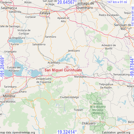
| Map corner | latitude | longitude |
|---|---|---|
| Upper-left | 20.64567°, | -101.28469° |
| Center: | 19.98629°, | -100.58156° |
| Lower-right: | 19.32414°, | -99.87844° |
| Map W x H: | 146.9×146.9 km | = 91.3×91.3mi |
| max Lat: | 32.7° ⇑43.3% North |
| San Miguel Curinhuato: | 19.98629° |
| min Lat: | ⇓56.7% South 14.53588° |
| min Long | San Miguel Curi | max Long |
| -117.105° | -100.58156° | -86.73105° |
| W 29.8%⇐ | ⇒70.2% E |
Elevation
Elevation of San Miguel Curinhuato is 2010 m = 6594 ft, and this is 756.3 m = 2481 ft above average elevation for this country.
| Max E: |
3497 m = 11473 ft | 26.1% |
| San Miguel Curinhuato | 2010 m 6594 ft | |
| Avg. | 1253.7 m = 4113 ft | |
Min E: |
-1 m = -3 ft | 73.9% |
See also: Mexico elevation on elevation.city.
Geographical zone
San Miguel Curinhuato is located in North Torrid zone (between Equator and Tropic of Cancer). Distance of this Northern Tropic circle is 383.7 km =238.4 mi to North.| Distance of | km | miles | from San Miguel Curinhuato |
|---|---|---|---|
| North Pole | 7784.8 | 4837.2 | to North |
| Arctic Circle | 5178.9 | 3218 | to North |
| Tropic Cancer | 383.7 | 238.4 | to North |
| Equator | 2222.3 | 1380.9 | to South |


Nearby cities:
15 places around San Miguel Curinhuato: (largest is in red/bold)
• Agua Caliente
11.4 km =7.1 mi,  301°
301°
• Arroyo Colorado
4.9 km =3 mi, 300°
• Arroyo de la Luna
4.3 km =2.7 mi,  343°
343°
• Barrio de San Miguel
6.4 km =4 mi,  140°
140°
• Buenavista
7.7 km =4.8 mi,  66°
66°
• Buenavista
9.4 km =5.8 mi,  221°
221°
• El Rodeo
5.2 km =3.2 mi,  238°
238°
• Heriberto Jara (La Presa)
8.5 km =5.3 mi,  193°
193°
• La Encarnación
11.2 km =7 mi,  329°
329°
• La Purísima
8.3 km =5.2 mi,  85°
85°
• Sabino Seco
10.9 km =6.8 mi, 65°
• San Ildefonso
7.6 km =4.7 mi,  210°
210°
• San Miguel
9.1 km =5.7 mi,  310°
310°
• Tarandacuao
6.8 km =4.2 mi,  76°
76°
• Uripitio
5.8 km =3.6 mi,  128°
128°
Sources, notices
• [Note1] Compared only with cities in Mexico existing in our database
• [Src1] Map data: © OpenStreetMap contributors (CC-BY-SA)
• [Src2] Other city data from geonames.org with taken over terms of usage.
• [Src3] Geographical zone / Annual Mean Temperature by Robert A. Rohde @ Wikipedia
