La Huerta geodata
La Huerta (Michoacán) is a populated place; located in Mexico in America/Mexico_City (GMT-6) time zone. With population of 571 people, there are 14980 cities with bigger population in this country. Compared to other cities in Mexico, 63.1% of cities are located further ↑North; 77.5% of cities are located further →East and 58.2% of cities have higher elevation than La Huerta. Note1


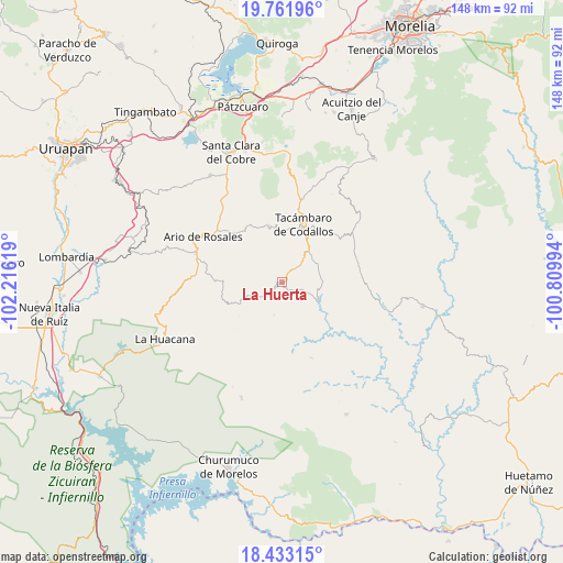
La Huerta GPS coordinates[2]
19° 5' 56.004" North, 101° 30' 47.016" West
| Map corner | latitude | longitude |
|---|---|---|
| Upper-left | 19.76196°, | -102.21619° |
| Center: | 19.09889°, | -101.51306° |
| Lower-right: | 18.43315°, | -100.80994° |
| Map W x H: | 147.7×147.8 km | = 91.8×91.8mi |
| max Lat: | 32.7° ⇑63.1% North |
| La Huerta: | 19.09889° |
| min Lat: | ⇓36.9% South 14.53588° |
| min Long | La Huerta | max Long |
| -117.105° | -101.51306° | -86.73105° |
| W 22.5%⇐ | ⇒77.5% E |
Elevation
Elevation of La Huerta is 1096 m = 3596 ft, and this is 157.7 m = 517 ft below average elevation for this country.
| Max E: |
3497 m = 11473 ft | 58.2% |
| Avg. | 1253.7 m = 4113 ft | |
| La Huerta | 1096 m = 3596 ft | |
Min E: |
-1 m = -3 ft | 41.8% |
See also: Mexico elevation on elevation.city.
Geographical zone
La Huerta is located in North Torrid zone (between Equator and Tropic of Cancer). Distance of this Northern Tropic circle is 482.3 km =299.7 mi to North.| Distance of | km | miles | from La Huerta |
|---|---|---|---|
| North Pole | 7883.5 | 4898.6 | to North |
| Arctic Circle | 5277.6 | 3279.3 | to North |
| Tropic Cancer | 482.3 | 299.7 | to North |
| Equator | 2123.6 | 1319.5 | to South |


Nearby cities:
15 places around La Huerta: (largest is in red/bold)
• Chupio
11.3 km =7 mi,  38°
38°
• El Cahulote de Santa Ana
7.7 km =4.8 mi,  250°
250°
• El Terrero
14.6 km =9.1 mi,  355°
355°
• La Ermita (Nueva Jerusalén)
2.8 km =1.7 mi,  166°
166°
• La Loma
13.6 km =8.5 mi,  46°
46°
• Las Joyas (El Poblado)
14.6 km =9.1 mi, 35°
• Los Hacheros
7.6 km =4.7 mi,  308°
308°
• Ojo de Agua de Chupio
10.5 km =6.5 mi,  65°
65°
• Pedernales
6.6 km =4.1 mi, 44°
• Petembo
3.3 km =2.1 mi, 38°
• Pinal Grande
6.5 km =4 mi,  272°
272°
• Puruarán
1 km =0.6 mi, 253°
• San Rafael Tecario
12.5 km =7.8 mi,  3°
3°
• Tavera
6.4 km =4 mi,  229°
229°
• Turicato
11.1 km =6.9 mi,  116°
116°
Sources, notices
• [Note1] Compared only with cities in Mexico existing in our database
• [Src1] Map data: © OpenStreetMap contributors (CC-BY-SA)
• [Src2] Other city data from geonames.org with taken over terms of usage.
• [Src3] Geographical zone / Annual Mean Temperature by Robert A. Rohde @ Wikipedia
