Pinal Grande geodata
Pinal Grande (Michoacán) is a populated place; located in Mexico in America/Mexico_City (GMT-6) time zone. With population of 782 people, there are 11169 cities with bigger population in this country. Compared to other cities in Mexico, 63.1% of cities are located further ↑North; 78% of cities are located further →East and 55.7% of cities have lower elevation than Pinal Grande. Note1


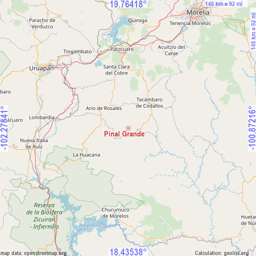
Pinal Grande GPS coordinates[2]
19° 6' 3.996" North, 101° 34' 31.008" West
| Map corner | latitude | longitude |
|---|---|---|
| Upper-left | 19.76418°, | -102.27841° |
| Center: | 19.10111°, | -101.57528° |
| Lower-right: | 18.43538°, | -100.87216° |
| Map W x H: | 147.7×147.8 km | = 91.8×91.8mi |
| max Lat: | 32.7° ⇑63.1% North |
| Pinal Grande: | 19.10111° |
| min Lat: | ⇓36.9% South 14.53588° |
| min Long | Pinal Grande | max Long |
| -117.105° | -101.57528° | -86.73105° |
| W 22%⇐ | ⇒78% E |
Elevation
Elevation of Pinal Grande is 1607 m = 5272 ft, and this is 353.3 m = 1159 ft above average elevation for this country.
| Max E: |
3497 m = 11473 ft | 44.3% |
| Pinal Grande | 1607 m 5272 ft | |
| Avg. | 1253.7 m = 4113 ft | |
Min E: |
-1 m = -3 ft | 55.7% |
See also: Mexico elevation on elevation.city.
Geographical zone
Pinal Grande is located in North Torrid zone (between Equator and Tropic of Cancer). Distance of this Northern Tropic circle is 482.1 km =299.6 mi to North.| Distance of | km | miles | from Pinal Grande |
|---|---|---|---|
| North Pole | 7883.2 | 4898.4 | to North |
| Arctic Circle | 5277.3 | 3279.2 | to North |
| Tropic Cancer | 482.1 | 299.6 | to North |
| Equator | 2123.8 | 1319.7 | to South |


Nearby cities:
15 places around Pinal Grande: (largest is in red/bold)
• El Cahulote de Santa Ana
2.9 km =1.8 mi,  195°
195°
• El Chupadero
11.2 km =7 mi,  328°
328°
• La Ermita (Nueva Jerusalén)
7.8 km =4.8 mi,  112°
112°
• La Huerta
6.5 km =4 mi,  92°
92°
• Las Puentes
10.6 km =6.6 mi,  230°
230°
• Los Hacheros
4.5 km =2.8 mi,  7°
7°
• Pedernales
12 km =7.5 mi,  68°
68°
• Petembo
8.9 km =5.5 mi, 74°
• Puruarán
5.6 km =3.5 mi,  95°
95°
• San José Grande
13.7 km =8.5 mi, 6°
• San Rafael Tecario
14.2 km =8.8 mi,  30°
30°
• Tavera
4.7 km =2.9 mi,  159°
159°
• Tecario
15 km =9.3 mi, 12°
• Urapa
10.7 km =6.6 mi,  271°
271°
• Zatzio (Tzatzio)
13.7 km =8.5 mi,  347°
347°
Sources, notices
• [Note1] Compared only with cities in Mexico existing in our database
• [Src1] Map data: © OpenStreetMap contributors (CC-BY-SA)
• [Src2] Other city data from geonames.org with taken over terms of usage.
• [Src3] Geographical zone / Annual Mean Temperature by Robert A. Rohde @ Wikipedia
