Turicato geodata
Turicato (Michoacán) is a seat of a second-order administrative division; located in Mexico in America/Mexico_City (GMT-6) time zone. With population of 2,132 people, there are 4107 cities with bigger population in this country. Compared to other cities in Mexico, 63.8% of cities are located further ↑North; 76.7% of cities are located further →East and 64.2% of cities have higher elevation than Turicato. Note1


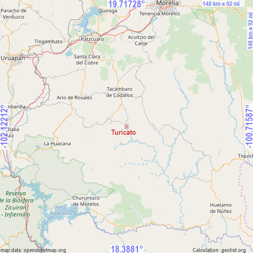
Turicato GPS coordinates[2]
19° 3' 14.472" North, 101° 25' 8.364" West
| Map corner | latitude | longitude |
|---|---|---|
| Upper-left | 19.71728°, | -102.12212° |
| Center: | 19.05402°, | -101.41899° |
| Lower-right: | 18.3881°, | -100.71587° |
| Map W x H: | 147.8×147.8 km | = 91.8×91.8mi |
| max Lat: | 32.7° ⇑63.8% North |
| Turicato: | 19.05402° |
| min Lat: | ⇓36.2% South 14.53588° |
| min Long | Turicato | max Long |
| -117.105° | -101.41899° | -86.73105° |
| W 23.3%⇐ | ⇒76.7% E |
Elevation
Elevation of Turicato is 739 m = 2425 ft, and this is 514.7 m = 1689 ft below average elevation for this country.
| Max E: |
3497 m = 11473 ft | 64.2% |
| Avg. | 1253.7 m = 4113 ft | |
| Turicato | 739 m = 2425 ft | |
Min E: |
-1 m = -3 ft | 35.8% |
See also: Mexico elevation on elevation.city.
Geographical zone
Turicato is located in North Torrid zone (between Equator and Tropic of Cancer). Distance of this Northern Tropic circle is 487.3 km =302.8 mi to North.| Distance of | km | miles | from Turicato |
|---|---|---|---|
| North Pole | 7888.5 | 4901.7 | to North |
| Arctic Circle | 5282.6 | 3282.5 | to North |
| Tropic Cancer | 487.3 | 302.8 | to North |
| Equator | 2118.6 | 1316.4 | to South |


Nearby cities:
15 places around Turicato: (largest is in red/bold)
• Chupio
14.1 km =8.8 mi,  348°
348°
• El Cahulote de Santa Ana
17.4 km =10.8 mi,  278°
278°
• La Ermita (Nueva Jerusalén)
9.5 km =5.9 mi, 283°
• La Huerta
11.1 km =6.9 mi,  296°
296°
• La Loma
14.3 km =8.9 mi,  359°
359°
• Las Joyas (El Poblado)
16.9 km =10.5 mi, 355°
• Los Hacheros
18.6 km =11.6 mi, 301°
• Melchor Ocampo
17 km =10.6 mi,  96°
96°
• Ojo de Agua de Chupio
9.3 km =5.8 mi, 357°
• Pedernales
11 km =6.8 mi,  331°
331°
• Petembo
10.9 km =6.8 mi,  314°
314°
• Pinal Grande
17.2 km =10.7 mi,  287°
287°
• Puruarán
11.8 km =7.3 mi, 293°
• San Rafael Tecario
19.7 km =12.2 mi, 332°
• Tavera
14.7 km =9.1 mi,  273°
273°
Sources, notices
• [Note1] Compared only with cities in Mexico existing in our database
• [Src1] Map data: © OpenStreetMap contributors (CC-BY-SA)
• [Src2] Other city data from geonames.org with taken over terms of usage.
• [Src3] Geographical zone / Annual Mean Temperature by Robert A. Rohde @ Wikipedia
