Picholco geodata
Picholco (San Luis Potosí) is a populated place; located in Mexico in America/Mexico_City (GMT-6) time zone. With population of 1,413 people, there are 6121 cities with bigger population in this country. Compared to other cities in Mexico, 80.8% of cities are located further ↓South; 52.7% of cities are located further ←West and 79% of cities have higher elevation than Picholco. Note1


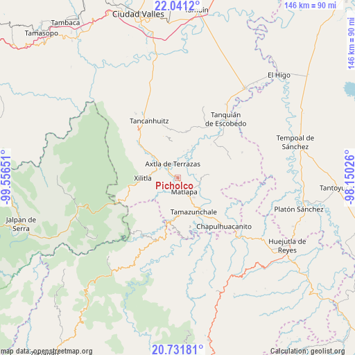
Picholco GPS coordinates[2]
21° 23' 16.692" North, 98° 51' 12.168" West
| Map corner | latitude | longitude |
|---|---|---|
| Upper-left | 22.0412°, | -99.55651° |
| Center: | 21.38797°, | -98.85338° |
| Lower-right: | 20.73181°, | -98.15026° |
| Map W x H: | 145.6×145.6 km | = 90.5×90.5mi |
| max Lat: | 32.7° ⇑19.2% North |
| Picholco: | 21.38797° |
| min Lat: | ⇓80.8% South 14.53588° |
| min Long | Picholco | max Long |
| -117.105° | -98.85338° | -86.73105° |
| W 52.7%⇐ | ⇒47.3% E |
Elevation
Elevation of Picholco is 112 m = 367 ft, and this is 1141.7 m = 3746 ft below average elevation for this country.
| Max E: |
3497 m = 11473 ft | 79% |
| Avg. | 1253.7 m = 4113 ft | |
| Picholco | 112 m = 367 ft | |
Min E: |
-1 m = -3 ft | 21% |
See also: Mexico elevation on elevation.city.
Geographical zone
Picholco is located in North Torrid zone (between Equator and Tropic of Cancer). Distance of this Northern Tropic circle is 227.8 km =141.5 mi to North.| Distance of | km | miles | from Picholco |
|---|---|---|---|
| North Pole | 7628.9 | 4740.4 | to North |
| Arctic Circle | 5023.1 | 3121.2 | to North |
| Tropic Cancer | 227.8 | 141.5 | to North |
| Equator | 2378.1 | 1477.7 | to South |


Nearby cities:
15 places around Picholco: (largest is in red/bold)
• Ahuacatitla
3.9 km =2.4 mi,  350°
350°
• Ahuehueyo Primero Centro
5.1 km =3.2 mi,  160°
160°
• Axtla de Terrazas
6.1 km =3.8 mi,  338°
338°
• Barrio de Arriba
6.7 km =4.2 mi, 157°
• Barrio de En Medio
5.9 km =3.7 mi, 162°
• Copalo (Chalco)
4.5 km =2.8 mi,  109°
109°
• Cuixcoatitla (Chalco)
5.3 km =3.3 mi,  120°
120°
• Ensenada (Chalco)
5.4 km =3.4 mi,  89°
89°
• Jalpilla
2.1 km =1.3 mi,  293°
293°
• Las Cuevas
3.5 km =2.2 mi,  219°
219°
• Matlapa
6.3 km =3.9 mi, 155°
• Papatlas
6.1 km =3.8 mi, 112°
• San Antonio
7 km =4.3 mi,  139°
139°
• Temalacaco
3 km =1.9 mi,  13°
13°
• Tenexio
3 km =1.9 mi,  245°
245°
Sources, notices
• [Note1] Compared only with cities in Mexico existing in our database
• [Src1] Map data: © OpenStreetMap contributors (CC-BY-SA)
• [Src2] Other city data from geonames.org with taken over terms of usage.
• [Src3] Geographical zone / Annual Mean Temperature by Robert A. Rohde @ Wikipedia
