Lázaro Cárdenas geodata
Lázaro Cárdenas (Sinaloa) is a populated place; located in Mexico in America/Mazatlan (GMT-7) time zone. With population of 568 people, there are 15043 cities with bigger population in this country. Compared to other cities in Mexico, 95.6% of cities are located further ↓South; 96.8% of cities are located further →East and 84.1% of cities have higher elevation than Lázaro Cárdenas. Note1


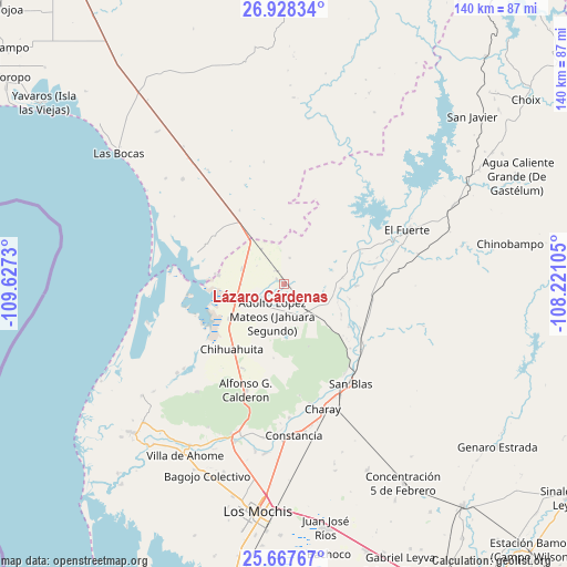
Lázaro Cárdenas GPS coordinates[2]
26° 17' 58.992" North, 108° 55' 27.012" West
| Map corner | latitude | longitude |
|---|---|---|
| Upper-left | 26.92834°, | -109.6273° |
| Center: | 26.29972°, | -108.92417° |
| Lower-right: | 25.66767°, | -108.22105° |
| Map W x H: | 140.2×140.2 km | = 87.1×87.1mi |
| max Lat: | 32.7° ⇑4.4% North |
| Lázaro Cárdenas: | 26.29972° |
| min Lat: | ⇓95.6% South 14.53588° |
| min Long | Lázaro Cárden | max Long |
| -117.105° | -108.92417° | -86.73105° |
| W 3.2%⇐ | ⇒96.8% E |
Elevation
Elevation of Lázaro Cárdenas is 51 m = 167 ft, and this is 1202.7 m = 3946 ft below average elevation for this country.
| Max E: |
3497 m = 11473 ft | 84.1% |
| Avg. | 1253.7 m = 4113 ft | |
| Lázaro Cárdenas | 51 m = 167 ft | |
Min E: |
-1 m = -3 ft | 15.9% |
See also: Mexico elevation on elevation.city.
Geographical zone
Lázaro Cárdenas is located in North temperate zone (between Tropic of Cancer and the Arctic Circle). Distance of this Northern Tropic circle is 318.3 km =197.8 mi to South.| Distance of | km | miles | from Lázaro Cárdenas |
|---|---|---|---|
| North Pole | 7082.8 | 4401 | to North |
| Arctic Circle | 4476.9 | 2781.8 | to North |
| Tropic Cancer | 318.3 | 197.8 | to South |
| Equator | 2924.3 | 1817.1 | to South |


Nearby cities:
15 places around Lázaro Cárdenas: (largest is in red/bold)
• Agiabampo Número Dos
17.4 km =10.8 mi,  278°
278°
• Bacorehuis
16.2 km =10.1 mi, 277°
• Boca de Arroyo
17.1 km =10.6 mi,  83°
83°
• Chihuahuita
20.7 km =12.9 mi,  218°
218°
• Colonia 12 de Agosto
8 km =5 mi,  192°
192°
• Emigdio Ruiz
12 km =7.5 mi,  314°
314°
• Juan de la Barrera
20.9 km =13 mi, 305°
• La Bajada del Monte
22.7 km =14.1 mi, 79°
• Las Estacas
16.5 km =10.3 mi,  103°
103°
• Palo Verde
1.7 km =1.1 mi,  336°
336°
• Poblado Número Cinco
16.2 km =10.1 mi,  237°
237°
• Revolución Mexicana
2.3 km =1.4 mi,  301°
301°
• Tehueco
17.9 km =11.1 mi,  91°
91°
• Tepic
5.3 km =3.3 mi, 192°
• Venustiano Carranza
17.3 km =10.7 mi,  322°
322°
Sources, notices
• [Note1] Compared only with cities in Mexico existing in our database
• [Src1] Map data: © OpenStreetMap contributors (CC-BY-SA)
• [Src2] Other city data from geonames.org with taken over terms of usage.
• [Src3] Geographical zone / Annual Mean Temperature by Robert A. Rohde @ Wikipedia
