Las Estacas geodata
Las Estacas (Sinaloa) is a populated place; located in Mexico in America/Mazatlan (GMT-7) time zone. With population of 509 people, there are 16517 cities with bigger population in this country. Compared to other cities in Mexico, 95.6% of cities are located further ↓South; 96.7% of cities are located further →East and 84.1% of cities have higher elevation than Las Estacas. Note1


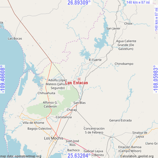
Las Estacas GPS coordinates[2]
26° 15' 51.408" North, 108° 45' 46.62" West
| Map corner | latitude | longitude |
|---|---|---|
| Upper-left | 26.89309°, | -109.46608° |
| Center: | 26.26428°, | -108.76295° |
| Lower-right: | 25.63204°, | -108.05983° |
| Map W x H: | 140.2×140.2 km | = 87.1×87.1mi |
| max Lat: | 32.7° ⇑4.4% North |
| Las Estacas: | 26.26428° |
| min Lat: | ⇓95.6% South 14.53588° |
| min Long | Las Estacas | max Long |
| -117.105° | -108.76295° | -86.73105° |
| W 3.3%⇐ | ⇒96.7% E |
Elevation
Elevation of Las Estacas is 51 m = 167 ft, and this is 1202.7 m = 3946 ft below average elevation for this country.
| Max E: |
3497 m = 11473 ft | 84.1% |
| Avg. | 1253.7 m = 4113 ft | |
| Las Estacas | 51 m = 167 ft | |
Min E: |
-1 m = -3 ft | 15.9% |
See also: Mexico elevation on elevation.city.
Geographical zone
Las Estacas is located in North temperate zone (between Tropic of Cancer and the Arctic Circle). Distance of this Northern Tropic circle is 314.4 km =195.4 mi to South.| Distance of | km | miles | from Las Estacas |
|---|---|---|---|
| North Pole | 7086.7 | 4403.5 | to North |
| Arctic Circle | 4480.9 | 2784.3 | to North |
| Tropic Cancer | 314.4 | 195.4 | to South |
| Equator | 2920.3 | 1814.6 | to South |


Nearby cities:
15 places around Las Estacas: (largest is in red/bold)
• Baroten
18.7 km =11.6 mi,  35°
35°
• Boca de Arroyo
5.9 km =3.7 mi,  8°
8°
• Colonia 12 de Agosto
18.3 km =11.4 mi,  257°
257°
• El Canutillo
18.4 km =11.4 mi,  48°
48°
• Estación Hoyancos (Estación el Fuerte)
20.4 km =12.7 mi,  55°
55°
• La Bajada del Monte
10.2 km =6.3 mi, 37°
• Lázaro Cárdenas
16.5 km =10.3 mi,  283°
283°
• Mulanjey
11.1 km =6.9 mi,  162°
162°
• Mulanjey (Estación Vega)
11.1 km =6.9 mi, 162°
• Palo Verde
17.6 km =10.9 mi,  288°
288°
• Revolución Mexicana
18.8 km =11.7 mi, 285°
• San Blas
20.5 km =12.7 mi,  179°
179°
• Sibajahui
13.1 km =8.1 mi,  168°
168°
• Tehueco
3.9 km =2.4 mi,  26°
26°
• Tepic
17.3 km =10.7 mi,  265°
265°
Sources, notices
• [Note1] Compared only with cities in Mexico existing in our database
• [Src1] Map data: © OpenStreetMap contributors (CC-BY-SA)
• [Src2] Other city data from geonames.org with taken over terms of usage.
• [Src3] Geographical zone / Annual Mean Temperature by Robert A. Rohde @ Wikipedia
