Puebla geodata
Puebla (Chiapas) is a populated place; located in Mexico in America/Mexico_City (GMT-6) time zone. With population of 1,245 people, there are 6968 cities with bigger population in this country. Compared to other cities in Mexico, 90.1% of cities are located further ↑North; 91.8% of cities are located further ←West and 50.8% of cities have higher elevation than Puebla. Note1


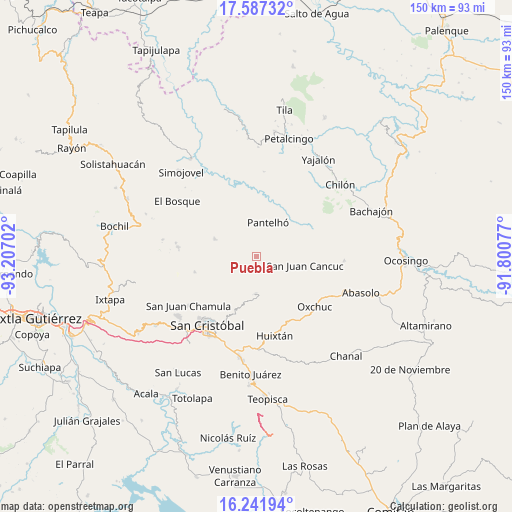
Puebla GPS coordinates[2]
16° 54' 56.988" North, 92° 30' 14.004" West
| Map corner | latitude | longitude |
|---|---|---|
| Upper-left | 17.58732°, | -93.20702° |
| Center: | 16.91583°, | -92.50389° |
| Lower-right: | 16.24194°, | -91.80077° |
| Map W x H: | 149.6×149.6 km | = 93×93mi |
| max Lat: | 32.7° ⇑90.1% North |
| Puebla: | 16.91583° |
| min Lat: | ⇓9.9% South 14.53588° |
| min Long | Puebla | max Long |
| -117.105° | -92.50389° | -86.73105° |
| W 91.8%⇐ | ⇒8.2% E |
Elevation
Elevation of Puebla is 1391 m = 4564 ft, and this is 137.3 m = 450 ft above average elevation for this country.
| Max E: |
3497 m = 11473 ft | 50.8% |
| Puebla | 1391 m 4564 ft | |
| Avg. | 1253.7 m = 4113 ft | |
Min E: |
-1 m = -3 ft | 49.2% |
See also: Mexico elevation on elevation.city.
Geographical zone
Puebla is located in North Torrid zone (between Equator and Tropic of Cancer). Distance of this Northern Tropic circle is 725.1 km =450.6 mi to North.| Distance of | km | miles | from Puebla |
|---|---|---|---|
| North Pole | 8126.2 | 5049.4 | to North |
| Arctic Circle | 5520.3 | 3430.2 | to North |
| Tropic Cancer | 725.1 | 450.6 | to North |
| Equator | 1880.9 | 1168.7 | to South |


Nearby cities:
15 places around Puebla: (largest is in red/bold)
• Alamul
4.1 km =2.5 mi,  215°
215°
• Cancuc
2.2 km =1.4 mi,  87°
87°
• Chacoma
4.6 km =2.9 mi,  163°
163°
• Chana
4.4 km =2.7 mi,  140°
140°
• Chimhucum
4.1 km =2.5 mi,  225°
225°
• Guayabal
4.1 km =2.5 mi,  31°
31°
• Jomanichim
3.8 km =2.4 mi,  116°
116°
• Juxalja
4.8 km =3 mi, 115°
• Miguel Utrilla (Los Chorros)
3.9 km =2.4 mi,  40°
40°
• Pactetón
2.8 km =1.7 mi, 117°
• Pulumsibac
5 km =3.1 mi, 220°
• Sivactel
2.8 km =1.7 mi,  197°
197°
• Tres Cerros
3.3 km =2.1 mi, 90°
• Tzeltal
3.8 km =2.4 mi,  46°
46°
• Yibeljoj
4.6 km =2.9 mi,  0°
0°
Sources, notices
• [Note1] Compared only with cities in Mexico existing in our database
• [Src1] Map data: © OpenStreetMap contributors (CC-BY-SA)
• [Src2] Other city data from geonames.org with taken over terms of usage.
• [Src3] Geographical zone / Annual Mean Temperature by Robert A. Rohde @ Wikipedia
