Tres Cerros geodata
Tres Cerros (Chiapas) is a populated place; located in Mexico in America/Mexico_City (GMT-6) time zone. With population of 1,228 people, there are 7063 cities with bigger population in this country. Compared to other cities in Mexico, 90.1% of cities are located further ↑North; 92.1% of cities are located further ←West and 52.4% of cities have higher elevation than Tres Cerros. Note1


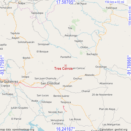
Tres Cerros GPS coordinates[2]
16° 54' 56.016" North, 92° 28' 22.008" West
| Map corner | latitude | longitude |
|---|---|---|
| Upper-left | 17.58705°, | -93.17591° |
| Center: | 16.91556°, | -92.47278° |
| Lower-right: | 16.24167°, | -91.76966° |
| Map W x H: | 149.6×149.6 km | = 93×93mi |
| max Lat: | 32.7° ⇑90.1% North |
| Tres Cerros: | 16.91556° |
| min Lat: | ⇓9.9% South 14.53588° |
| min Long | Tres Cerros | max Long |
| -117.105° | -92.47278° | -86.73105° |
| W 92.1%⇐ | ⇒7.9% E |
Elevation
Elevation of Tres Cerros is 1321 m = 4334 ft, and this is 67.3 m = 221 ft above average elevation for this country.
| Max E: |
3497 m = 11473 ft | 52.4% |
| Tres Cerros | 1321 m 4334 ft | |
| Avg. | 1253.7 m = 4113 ft | |
Min E: |
-1 m = -3 ft | 47.6% |
See also: Mexico elevation on elevation.city.
Geographical zone
Tres Cerros is located in North Torrid zone (between Equator and Tropic of Cancer). Distance of this Northern Tropic circle is 725.1 km =450.6 mi to North.| Distance of | km | miles | from Tres Cerros |
|---|---|---|---|
| North Pole | 8126.2 | 5049.4 | to North |
| Arctic Circle | 5520.3 | 3430.2 | to North |
| Tropic Cancer | 725.1 | 450.6 | to North |
| Equator | 1880.8 | 1168.7 | to South |


Nearby cities:
15 places around Tres Cerros: (largest is in red/bold)
• Amaquil (Patio Amplio)
2.2 km =1.4 mi,  74°
74°
• Cancuc
1.1 km =0.7 mi,  276°
276°
• Chana
3.4 km =2.1 mi,  188°
188°
• Chixtontic
3.2 km =2 mi,  150°
150°
• Cruz Pilar
2.7 km =1.7 mi,  107°
107°
• Guayabal
3.7 km =2.3 mi,  341°
341°
• Jomanichim
1.7 km =1.1 mi,  177°
177°
• Juxalja
2.3 km =1.4 mi, 152°
• Kulaktik
4.7 km =2.9 mi, 182°
• Miguel Utrilla (Los Chorros)
3.1 km =1.9 mi,  346°
346°
• Pactetón
1.5 km =0.9 mi,  213°
213°
• Puebla
3.3 km =2.1 mi,  270°
270°
• Sibaniljá Pocolum
4.5 km =2.8 mi,  164°
164°
• Tzeltal
2.7 km =1.7 mi, 348°
• Yetzucum
4.7 km =2.9 mi,  138°
138°
Sources, notices
• [Note1] Compared only with cities in Mexico existing in our database
• [Src1] Map data: © OpenStreetMap contributors (CC-BY-SA)
• [Src2] Other city data from geonames.org with taken over terms of usage.
• [Src3] Geographical zone / Annual Mean Temperature by Robert A. Rohde @ Wikipedia
