Santa Rosa geodata
Santa Rosa (Mexico City) is a populated place; located in Mexico in America/Mexico_City (GMT-6) time zone. With population of 518 people, there are 16254 cities with bigger population in this country. Compared to other cities in Mexico, 58.3% of cities are located further ↑North; 54.2% of cities are located further →East and 99.2% of cities have lower elevation than Santa Rosa. Note1


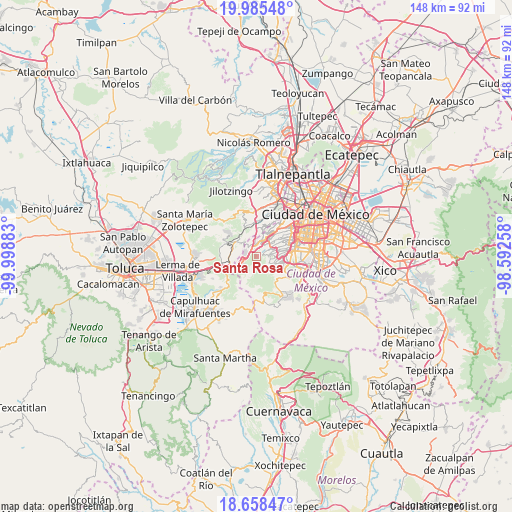
Santa Rosa GPS coordinates[2]
19° 19' 23.952" North, 99° 17' 44.52" West
| Map corner | latitude | longitude |
|---|---|---|
| Upper-left | 19.98548°, | -99.99883° |
| Center: | 19.32332°, | -99.2957° |
| Lower-right: | 18.65847°, | -98.59258° |
| Map W x H: | 147.5×147.6 km | = 91.7×91.7mi |
| max Lat: | 32.7° ⇑58.3% North |
| Santa Rosa: | 19.32332° |
| min Lat: | ⇓41.7% South 14.53588° |
| min Long | Santa Rosa | max Long |
| -117.105° | -99.2957° | -86.73105° |
| W 45.8%⇐ | ⇒54.2% E |
Elevation
Elevation of Santa Rosa is 2858 m = 9377 ft, and this is 1604.3 m = 5263 ft above average elevation for this country.
| Max E: |
3497 m = 11473 ft | 0.8% |
| Santa Rosa | 2858 m 9377 ft | |
| Avg. | 1253.7 m = 4113 ft | |
Min E: |
-1 m = -3 ft | 99.2% |
See also: Mexico elevation on elevation.city.
Geographical zone
Santa Rosa is located in North Torrid zone (between Equator and Tropic of Cancer). Distance of this Northern Tropic circle is 457.4 km =284.2 mi to North.| Distance of | km | miles | from Santa Rosa |
|---|---|---|---|
| North Pole | 7858.5 | 4883 | to North |
| Arctic Circle | 5252.6 | 3263.8 | to North |
| Tropic Cancer | 457.4 | 284.2 | to North |
| Equator | 2148.6 | 1335.1 | to South |


Nearby cities:
15 places around Santa Rosa: (largest is in red/bold)
• Barrio de San Ramón
6.7 km =4.2 mi,  326°
326°
• Col. Bosques de las Lomas
6.9 km =4.3 mi,  26°
26°
• Colonia La Venta
2.1 km =1.3 mi,  307°
307°
• Cruz Blanca
3 km =1.9 mi,  259°
259°
• Delegación Cuajimalpa de Morelos
5.1 km =3.2 mi,  5°
5°
• El Cerrito
6.6 km =4.1 mi,  302°
302°
• El Mirasol
4.8 km =3 mi, 307°
• Huixquilucan
7 km =4.3 mi, 305°
• Huixquilucan de Degollado
7 km =4.3 mi, 305°
• Jesús del Monte
5.7 km =3.5 mi,  1°
1°
• San Jacinto
5.3 km =3.3 mi, 326°
• San Juan Yautepec
5.5 km =3.4 mi, 301°
• San Lorenzo Acopilco
3.4 km =2.1 mi,  282°
282°
• Santiago Yancuitlalpan
6.8 km =4.2 mi,  352°
352°
• Zacamulpa
5.2 km =3.2 mi, 313°
Sources, notices
• [Note1] Compared only with cities in Mexico existing in our database
• [Src1] Map data: © OpenStreetMap contributors (CC-BY-SA)
• [Src2] Other city data from geonames.org with taken over terms of usage.
• [Src3] Geographical zone / Annual Mean Temperature by Robert A. Rohde @ Wikipedia
