Anayal Número Uno geodata
Anayal Número Uno (Veracruz) is a populated place; located in Mexico in America/Mexico_City (GMT-6) time zone. With population of 518 people, there are 16254 cities with bigger population in this country. Compared to other cities in Mexico, 59.9% of cities are located further ↓South; 68.9% of cities are located further ←West and 70.1% of cities have higher elevation than Anayal Número Uno. Note1


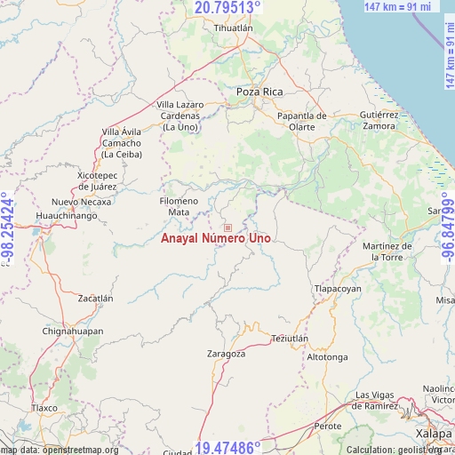
Anayal Número Uno GPS coordinates[2]
20° 8' 11.004" North, 97° 33' 3.996" West
| Map corner | latitude | longitude |
|---|---|---|
| Upper-left | 20.79513°, | -98.25424° |
| Center: | 20.13639°, | -97.55111° |
| Lower-right: | 19.47486°, | -96.84799° |
| Map W x H: | 146.8×146.8 km | = 91.2×91.2mi |
| max Lat: | 32.7° ⇑40.1% North |
| Anayal Número Uno: | 20.13639° |
| min Lat: | ⇓59.9% South 14.53588° |
| min Long | Anayal Número | max Long |
| -117.105° | -97.55111° | -86.73105° |
| W 68.9%⇐ | ⇒31.1% E |
Elevation
Elevation of Anayal Número Uno is 411 m = 1348 ft, and this is 842.7 m = 2765 ft below average elevation for this country.
| Max E: |
3497 m = 11473 ft | 70.1% |
| Avg. | 1253.7 m = 4113 ft | |
| Anayal Número Uno | 411 m = 1348 ft | |
Min E: |
-1 m = -3 ft | 29.9% |
See also: Mexico elevation on elevation.city.
Geographical zone
Anayal Número Uno is located in North Torrid zone (between Equator and Tropic of Cancer). Distance of this Northern Tropic circle is 367 km =228 mi to North.| Distance of | km | miles | from Anayal Número Uno |
|---|---|---|---|
| North Pole | 7768.1 | 4826.9 | to North |
| Arctic Circle | 5162.2 | 3207.6 | to North |
| Tropic Cancer | 367 | 228 | to North |
| Equator | 2239 | 1391.2 | to South |


Nearby cities:
15 places around Anayal Número Uno: (largest is in red/bold)
• Acatzácatl
4.5 km =2.8 mi,  230°
230°
• Caxuxuman
1.7 km =1.1 mi,  36°
36°
• Chihuixcruz
5.9 km =3.7 mi,  31°
31°
• Coxquihui
6.4 km =4 mi,  325°
325°
• Francisco I. Madero
6 km =3.7 mi,  236°
236°
• Reyes de Vallarta
3.8 km =2.4 mi,  147°
147°
• Santa Isabel
6.6 km =4.1 mi,  20°
20°
• Tahuaxni Norte
3.9 km =2.4 mi,  309°
309°
• Tecuantepec
5.4 km =3.4 mi,  79°
79°
• Xalcuahuta
6.8 km =4.2 mi,  142°
142°
• Xaltipan
5.7 km =3.5 mi,  158°
158°
• Xonalpu
6.3 km =3.9 mi,  261°
261°
• Zapotal
2.7 km =1.7 mi,  13°
13°
• Zozocolco de Guerrero
4.1 km =2.5 mi,  207°
207°
• Zozocolco de Hidalgo
2.6 km =1.6 mi,  280°
280°
Sources, notices
• [Note1] Compared only with cities in Mexico existing in our database
• [Src1] Map data: © OpenStreetMap contributors (CC-BY-SA)
• [Src2] Other city data from geonames.org with taken over terms of usage.
• [Src3] Geographical zone / Annual Mean Temperature by Robert A. Rohde @ Wikipedia
