Chihuixcruz geodata
Chihuixcruz (Veracruz) is a populated place; located in Mexico in America/Mexico_City (GMT-6) time zone. With population of 505 people, there are 16660 cities with bigger population in this country. Compared to other cities in Mexico, 61% of cities are located further ↓South; 69.3% of cities are located further ←West and 77.9% of cities have higher elevation than Chihuixcruz. Note1


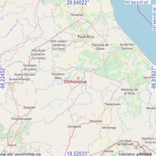
Chihuixcruz GPS coordinates[2]
20° 10' 54.012" North, 97° 31' 17.004" West
| Map corner | latitude | longitude |
|---|---|---|
| Upper-left | 20.84022°, | -98.22452° |
| Center: | 20.18167°, | -97.52139° |
| Lower-right: | 19.52033°, | -96.81827° |
| Map W x H: | 146.8×146.8 km | = 91.2×91.2mi |
| max Lat: | 32.7° ⇑39% North |
| Chihuixcruz: | 20.18167° |
| min Lat: | ⇓61% South 14.53588° |
| min Long | Chihuixcruz | max Long |
| -117.105° | -97.52139° | -86.73105° |
| W 69.3%⇐ | ⇒30.7% E |
Elevation
Elevation of Chihuixcruz is 132 m = 433 ft, and this is 1121.7 m = 3680 ft below average elevation for this country.
| Max E: |
3497 m = 11473 ft | 77.9% |
| Avg. | 1253.7 m = 4113 ft | |
| Chihuixcruz | 132 m = 433 ft | |
Min E: |
-1 m = -3 ft | 22.1% |
See also: Mexico elevation on elevation.city.
Geographical zone
Chihuixcruz is located in North Torrid zone (between Equator and Tropic of Cancer). Distance of this Northern Tropic circle is 361.9 km =224.9 mi to North.| Distance of | km | miles | from Chihuixcruz |
|---|---|---|---|
| North Pole | 7763.1 | 4823.8 | to North |
| Arctic Circle | 5157.2 | 3204.5 | to North |
| Tropic Cancer | 361.9 | 224.9 | to North |
| Equator | 2244 | 1394.4 | to South |


Nearby cities:
15 places around Chihuixcruz: (largest is in red/bold)
• Adolfo Ruiz Cortines
6.1 km =3.8 mi,  317°
317°
• Anayal Número Uno
5.9 km =3.7 mi,  211°
211°
• Caxuxuman
4.2 km =2.6 mi, 209°
• Chapultepec
3.6 km =2.2 mi, 316°
• Coxquihui
6.7 km =4.2 mi,  272°
272°
• El Arenal
7.8 km =4.8 mi,  4°
4°
• El Ermitaño
3 km =1.9 mi,  20°
20°
• José María Morelos
4.4 km =2.7 mi,  327°
327°
• Sabanas de Xalostoc
4.7 km =2.9 mi,  342°
342°
• Santa Isabel
1.4 km =0.9 mi, 325°
• Tahuaxni Norte
6.6 km =4.1 mi,  247°
247°
• Tecuantepec
4.7 km =2.9 mi,  151°
151°
• Zacate Limón
4.9 km =3 mi,  356°
356°
• Zapotal
3.5 km =2.2 mi,  225°
225°
• Zozocolco de Hidalgo
7.3 km =4.5 mi, 231°
Sources, notices
• [Note1] Compared only with cities in Mexico existing in our database
• [Src1] Map data: © OpenStreetMap contributors (CC-BY-SA)
• [Src2] Other city data from geonames.org with taken over terms of usage.
• [Src3] Geographical zone / Annual Mean Temperature by Robert A. Rohde @ Wikipedia
