Nuevo México geodata
Nuevo México (Chiapas) is a populated place; located in Mexico in America/Mexico_City (GMT-6) time zone. With population of 512 people, there are 16417 cities with bigger population in this country. Compared to other cities in Mexico, 86.5% of cities are located further ↑North; 86.4% of cities are located further ←West and 79.6% of cities have higher elevation than Nuevo México. Note1


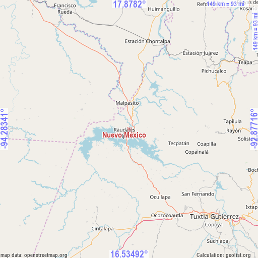
Nuevo México GPS coordinates[2]
17° 12' 28.008" North, 93° 34' 49.008" West
| Map corner | latitude | longitude |
|---|---|---|
| Upper-left | 17.8782°, | -94.28341° |
| Center: | 17.20778°, | -93.58028° |
| Lower-right: | 16.53492°, | -92.87716° |
| Map W x H: | 149.4×149.4 km | = 92.8×92.8mi |
| max Lat: | 32.7° ⇑86.5% North |
| Nuevo México: | 17.20778° |
| min Lat: | ⇓13.5% South 14.53588° |
| min Long | Nuevo México | max Long |
| -117.105° | -93.58028° | -86.73105° |
| W 86.4%⇐ | ⇒13.6% E |
Elevation
Elevation of Nuevo México is 101 m = 331 ft, and this is 1152.7 m = 3782 ft below average elevation for this country.
| Max E: |
3497 m = 11473 ft | 79.6% |
| Avg. | 1253.7 m = 4113 ft | |
| Nuevo México | 101 m = 331 ft | |
Min E: |
-1 m = -3 ft | 20.4% |
See also: Mexico elevation on elevation.city.
Geographical zone
Nuevo México is located in North Torrid zone (between Equator and Tropic of Cancer). Distance of this Northern Tropic circle is 692.6 km =430.4 mi to North.| Distance of | km | miles | from Nuevo México |
|---|---|---|---|
| North Pole | 8093.7 | 5029.2 | to North |
| Arctic Circle | 5487.8 | 3410 | to North |
| Tropic Cancer | 692.6 | 430.4 | to North |
| Equator | 1913.3 | 1188.9 | to South |


Nearby cities:
15 places around Nuevo México: (largest is in red/bold)
• Adolfo López Mateos
10.8 km =6.7 mi,  85°
85°
• Amatán
13.4 km =8.3 mi,  304°
304°
• Angel Albino Corzo
4.6 km =2.9 mi,  285°
285°
• Campamento General Emiliano Zapata
9.7 km =6 mi,  11°
11°
• El Progreso (Chintul)
3.5 km =2.2 mi,  356°
356°
• Esperanza de los Pobres
15.3 km =9.5 mi,  41°
41°
• Juan Sabines Gutiérrez
17.6 km =10.9 mi,  79°
79°
• Juan de Grijalva
17.8 km =11.1 mi,  157°
157°
• Licenciado Luis Echeverría Álvarez (Playa Santa)
14.9 km =9.3 mi,  324°
324°
• Luis Espinoza
17.9 km =11.1 mi,  110°
110°
• Miguel Hidalgo y Costilla
15.5 km =9.6 mi,  64°
64°
• Nuevo Naranjo
16.7 km =10.4 mi, 110°
• Raudales Malpaso
3.5 km =2.2 mi,  231°
231°
• Rómulo Calzada (La Herradura)
15.2 km =9.4 mi, 10°
• Santos Degollado
15.3 km =9.5 mi, 11°
Sources, notices
• [Note1] Compared only with cities in Mexico existing in our database
• [Src1] Map data: © OpenStreetMap contributors (CC-BY-SA)
• [Src2] Other city data from geonames.org with taken over terms of usage.
• [Src3] Geographical zone / Annual Mean Temperature by Robert A. Rohde @ Wikipedia
