Cuartillo Nuevo geodata
Cuartillo Nuevo (San Luis Potosí) is a populated place; located in Mexico in America/Mexico_City (GMT-6) time zone. With population of 511 people, there are 16451 cities with bigger population in this country. Compared to other cities in Mexico, 80.5% of cities are located further ↓South; 51.2% of cities are located further ←West and 63.6% of cities have higher elevation than Cuartillo Nuevo. Note1


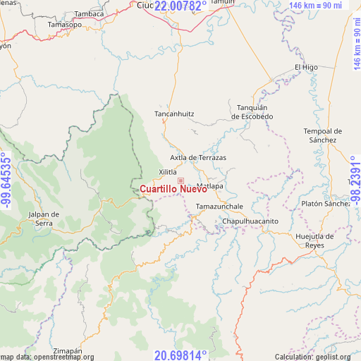
Cuartillo Nuevo GPS coordinates[2]
21° 21' 15.984" North, 98° 56' 31.992" West
| Map corner | latitude | longitude |
|---|---|---|
| Upper-left | 22.00782°, | -99.64535° |
| Center: | 21.35444°, | -98.94222° |
| Lower-right: | 20.69814°, | -98.2391° |
| Map W x H: | 145.6×145.6 km | = 90.5×90.5mi |
| max Lat: | 32.7° ⇑19.5% North |
| Cuartillo Nuevo: | 21.35444° |
| min Lat: | ⇓80.5% South 14.53588° |
| min Long | Cuartillo Nuevo | max Long |
| -117.105° | -98.94222° | -86.73105° |
| W 51.2%⇐ | ⇒48.8% E |
Elevation
Elevation of Cuartillo Nuevo is 773 m = 2536 ft, and this is 480.7 m = 1577 ft below average elevation for this country.
| Max E: |
3497 m = 11473 ft | 63.6% |
| Avg. | 1253.7 m = 4113 ft | |
| Cuartillo Nuevo | 773 m = 2536 ft | |
Min E: |
-1 m = -3 ft | 36.4% |
See also: Mexico elevation on elevation.city.
Geographical zone
Cuartillo Nuevo is located in North Torrid zone (between Equator and Tropic of Cancer). Distance of this Northern Tropic circle is 231.5 km =143.8 mi to North.| Distance of | km | miles | from Cuartillo Nuevo |
|---|---|---|---|
| North Pole | 7632.7 | 4742.7 | to North |
| Arctic Circle | 5026.8 | 3123.5 | to North |
| Tropic Cancer | 231.5 | 143.8 | to North |
| Equator | 2374.4 | 1475.4 | to South |


Nearby cities:
15 places around Cuartillo Nuevo: (largest is in red/bold)
• Coaquentla
6.8 km =4.2 mi,  134°
134°
• Iztacapa
1.7 km =1.1 mi,  1°
1°
• Las Cuevas
7.1 km =4.4 mi,  81°
81°
• Las Moras
7.4 km =4.6 mi,  183°
183°
• Pahuayo Primero
6.2 km =3.9 mi, 127°
• Pemoxco
0.9 km =0.6 mi,  21°
21°
• Pilateno
3.8 km =2.4 mi,  227°
227°
• Sabino
4.8 km =3 mi,  215°
215°
• Tenexio
7 km =4.3 mi,  69°
69°
• Tlacohuaque
4.1 km =2.5 mi,  119°
119°
• Tlacuapa (Temascal)
7.3 km =4.5 mi,  357°
357°
• Uxtuapan
3.5 km =2.2 mi,  286°
286°
• Xilitla
6.1 km =3.8 mi,  305°
305°
• Zacayo
5 km =3.1 mi,  143°
143°
• Zapuyo
2.2 km =1.4 mi,  89°
89°
Sources, notices
• [Note1] Compared only with cities in Mexico existing in our database
• [Src1] Map data: © OpenStreetMap contributors (CC-BY-SA)
• [Src2] Other city data from geonames.org with taken over terms of usage.
• [Src3] Geographical zone / Annual Mean Temperature by Robert A. Rohde @ Wikipedia
