Sabino geodata
Sabino (Hidalgo) is a populated place; located in Mexico in America/Mexico_City (GMT-6) time zone. With population of 656 people, there are 13229 cities with bigger population in this country. Compared to other cities in Mexico, 80.2% of cities are located further ↓South; 50.7% of cities are located further ←West and 68.1% of cities have higher elevation than Sabino. Note1


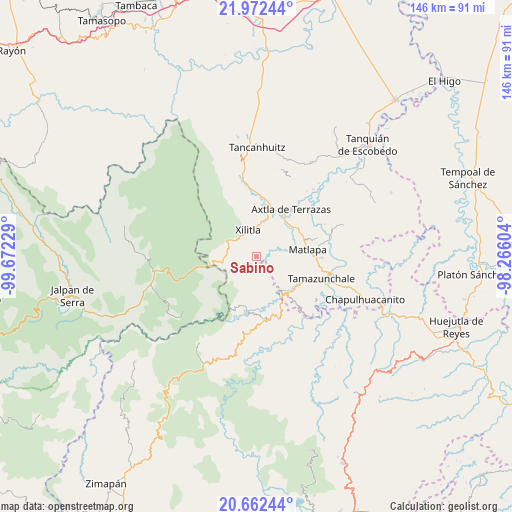
Sabino GPS coordinates[2]
21° 19' 8.04" North, 98° 58' 8.976" West
| Map corner | latitude | longitude |
|---|---|---|
| Upper-left | 21.97244°, | -99.67229° |
| Center: | 21.3189°, | -98.96916° |
| Lower-right: | 20.66244°, | -98.26604° |
| Map W x H: | 145.7×145.7 km | = 90.5×90.5mi |
| max Lat: | 32.7° ⇑19.8% North |
| Sabino: | 21.3189° |
| min Lat: | ⇓80.2% South 14.53588° |
| min Long | Sabino | max Long |
| -117.105° | -98.96916° | -86.73105° |
| W 50.7%⇐ | ⇒49.3% E |
Elevation
Elevation of Sabino is 528 m = 1732 ft, and this is 725.7 m = 2381 ft below average elevation for this country.
| Max E: |
3497 m = 11473 ft | 68.1% |
| Avg. | 1253.7 m = 4113 ft | |
| Sabino | 528 m = 1732 ft | |
Min E: |
-1 m = -3 ft | 31.9% |
See also: Mexico elevation on elevation.city.
Geographical zone
Sabino is located in North Torrid zone (between Equator and Tropic of Cancer). Distance of this Northern Tropic circle is 235.5 km =146.3 mi to North.| Distance of | km | miles | from Sabino |
|---|---|---|---|
| North Pole | 7636.6 | 4745.2 | to North |
| Arctic Circle | 5030.7 | 3125.9 | to North |
| Tropic Cancer | 235.5 | 146.3 | to North |
| Equator | 2370.4 | 1472.9 | to South |


Nearby cities:
15 places around Sabino: (largest is in red/bold)
• Coaquentla
7.7 km =4.8 mi,  96°
96°
• Cuartillo Nuevo
4.8 km =3 mi,  35°
35°
• Gargantilla
6.1 km =3.8 mi,  168°
168°
• Iztacapa
6.4 km =4 mi,  26°
26°
• La Ameca
8.9 km =5.5 mi,  152°
152°
• La Arena
5.5 km =3.4 mi,  158°
158°
• Las Moras
4.2 km =2.6 mi, 145°
• Pahuayo Primero
7.7 km =4.8 mi,  89°
89°
• Pemoxco
5.7 km =3.5 mi, 33°
• Pilateno
1.4 km =0.9 mi,  359°
359°
• Tlacohuaque
6.6 km =4.1 mi,  73°
73°
• Uxtuapan
5 km =3.1 mi,  353°
353°
• Xilitla
7.9 km =4.9 mi,  343°
343°
• Zacayo
5.8 km =3.6 mi, 90°
• Zapuyo
6.4 km =4 mi,  51°
51°
Sources, notices
• [Note1] Compared only with cities in Mexico existing in our database
• [Src1] Map data: © OpenStreetMap contributors (CC-BY-SA)
• [Src2] Other city data from geonames.org with taken over terms of usage.
• [Src3] Geographical zone / Annual Mean Temperature by Robert A. Rohde @ Wikipedia
