Macuilocatl geodata
Macuilocatl (San Luis Potosí) is a populated place; located in Mexico in America/Mexico_City (GMT-6) time zone. With population of 504 people, there are 16693 cities with bigger population in this country. Compared to other cities in Mexico, 80.7% of cities are located further ↓South; 54.6% of cities are located further ←West and 76.1% of cities have higher elevation than Macuilocatl. Note1


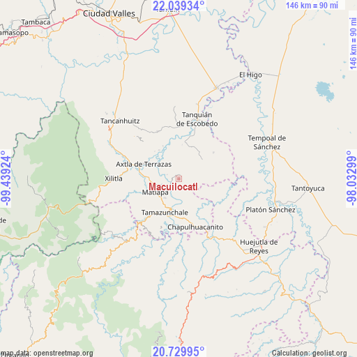
Macuilocatl GPS coordinates[2]
21° 23' 9.996" North, 98° 44' 9.996" West
| Map corner | latitude | longitude |
|---|---|---|
| Upper-left | 22.03934°, | -99.43924° |
| Center: | 21.38611°, | -98.73611° |
| Lower-right: | 20.72995°, | -98.03299° |
| Map W x H: | 145.6×145.6 km | = 90.5×90.5mi |
| max Lat: | 32.7° ⇑19.3% North |
| Macuilocatl: | 21.38611° |
| min Lat: | ⇓80.7% South 14.53588° |
| min Long | Macuilocatl | max Long |
| -117.105° | -98.73611° | -86.73105° |
| W 54.6%⇐ | ⇒45.4% E |
Elevation
Elevation of Macuilocatl is 184 m = 604 ft, and this is 1069.7 m = 3510 ft below average elevation for this country.
| Max E: |
3497 m = 11473 ft | 76.1% |
| Avg. | 1253.7 m = 4113 ft | |
| Macuilocatl | 184 m = 604 ft | |
Min E: |
-1 m = -3 ft | 23.9% |
See also: Mexico elevation on elevation.city.
Geographical zone
Macuilocatl is located in North Torrid zone (between Equator and Tropic of Cancer). Distance of this Northern Tropic circle is 228 km =141.7 mi to North.| Distance of | km | miles | from Macuilocatl |
|---|---|---|---|
| North Pole | 7629.1 | 4740.5 | to North |
| Arctic Circle | 5023.3 | 3121.3 | to North |
| Tropic Cancer | 228 | 141.7 | to North |
| Equator | 2377.9 | 1477.6 | to South |


Nearby cities:
15 places around Macuilocatl: (largest is in red/bold)
• Chiconamel
2.7 km =1.7 mi,  138°
138°
• Chililillo
2.1 km =1.3 mi,  304°
304°
• Copalo (Chalco)
8 km =5 mi,  260°
260°
• Cuixcoatitla (Chalco)
7.9 km =4.9 mi,  251°
251°
• El Huexco
5.4 km =3.4 mi,  199°
199°
• Ensenada (Chalco)
6.7 km =4.2 mi,  272°
272°
• Escoatitla
6.7 km =4.2 mi,  149°
149°
• La Soledad
1.4 km =0.9 mi,  62°
62°
• Manchoc
6.5 km =4 mi, 136°
• Ocuiltzapoyo
6.9 km =4.3 mi,  173°
173°
• Papatlas
6.8 km =4.2 mi, 251°
• Tampacán
1.9 km =1.2 mi,  24°
24°
• Tenextitla Dos
3.4 km =2.1 mi,  120°
120°
• Totomoxtla (La Ceiba)
3.1 km =1.9 mi, 251°
• Xochicuatla
3.1 km =1.9 mi,  177°
177°
Sources, notices
• [Note1] Compared only with cities in Mexico existing in our database
• [Src1] Map data: © OpenStreetMap contributors (CC-BY-SA)
• [Src2] Other city data from geonames.org with taken over terms of usage.
• [Src3] Geographical zone / Annual Mean Temperature by Robert A. Rohde @ Wikipedia
