Nezahualcóyotl geodata
Nezahualcóyotl (State of Mexico) is a seat of a second-order administrative division; located in Mexico in America/Mexico_City (GMT-6) time zone. In our database, there are 16903 cities with bigger population. Compared to other cities in Mexico, 56.6% of cities are located further ↑North; 50.3% of cities are located further ←West and 83.6% of cities have lower elevation than Nezahualcóyotl. Note1


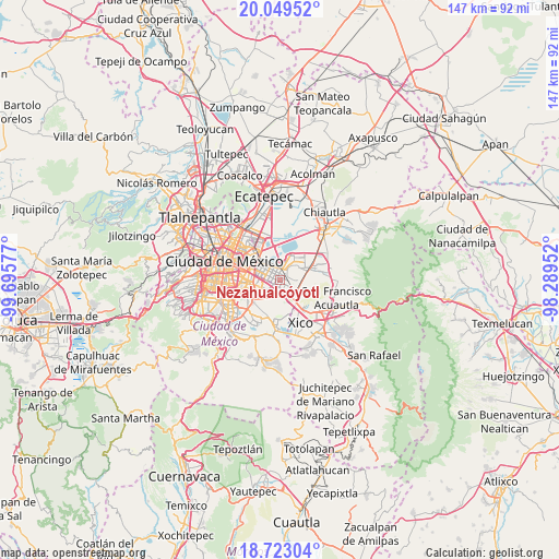
Nezahualcóyotl GPS coordinates[2]
19° 23' 15.468" North, 98° 59' 33.504" West
| Map corner | latitude | longitude |
|---|---|---|
| Upper-left | 20.04952°, | -99.69577° |
| Center: | 19.38763°, | -98.99264° |
| Lower-right: | 18.72304°, | -98.28952° |
| Map W x H: | 147.5×147.5 km | = 91.7×91.7mi |
| max Lat: | 32.7° ⇑56.6% North |
| Nezahualcóyotl: | 19.38763° |
| min Lat: | ⇓43.4% South 14.53588° |
| min Long | Nezahualcóyotl | max Long |
| -117.105° | -98.99264° | -86.73105° |
| W 50.3%⇐ | ⇒49.7% E |
Elevation
Elevation of Nezahualcóyotl is 2234 m = 7329 ft, and this is 980.3 m = 3216 ft above average elevation for this country.
| Max E: |
3497 m = 11473 ft | 16.4% |
| Nezahualcóyotl | 2234 m 7329 ft | |
| Avg. | 1253.7 m = 4113 ft | |
Min E: |
-1 m = -3 ft | 83.6% |
See also: Mexico elevation on elevation.city.
Geographical zone
Nezahualcóyotl is located in North Torrid zone (between Equator and Tropic of Cancer). Distance of this Northern Tropic circle is 450.2 km =279.7 mi to North.| Distance of | km | miles | from Nezahualcóyotl |
|---|---|---|---|
| North Pole | 7851.4 | 4878.6 | to North |
| Arctic Circle | 5245.5 | 3259.4 | to North |
| Tropic Cancer | 450.2 | 279.7 | to North |
| Equator | 2155.7 | 1339.5 | to South |


Nearby cities:
15 places around Nezahualcóyotl: (largest is in red/bold)
• Arenal
5.3 km =3.3 mi,  97°
97°
• Bosques de la Magdalena
5.8 km =3.6 mi,  125°
125°
• Ciudad Nezahualcoyotl
2.7 km =1.7 mi,  301°
301°
• Colonia Gustavo Baz Prada
4.4 km =2.7 mi,  329°
329°
• Emiliano Zapata
5.2 km =3.2 mi,  158°
158°
• Lomas de Altavista
5.8 km =3.6 mi,  120°
120°
• Los Reyes Acaquilpan
3.1 km =1.9 mi,  148°
148°
• Magdalena Atlicpac
5 km =3.1 mi,  114°
114°
• Polígonos
3.2 km =2 mi,  3°
3°
• Profesor Carlos Hank González
5.9 km =3.7 mi, 106°
• San Sebastián Chimalpa
4 km =2.5 mi, 99°
• Santa María Chimalhuacán
5.8 km =3.6 mi,  49°
49°
• Tecamachalco
4.6 km =2.9 mi, 131°
• Techachaltitla
6 km =3.7 mi, 114°
• Unidad Acaquilpan
6.1 km =3.8 mi, 112°
In other languages:
- In Spanish: Nezahualcóyotl, Ciudad Netzahualcoyotl, Ciudad Nezahualcoyotl, Ciudad Nezahualcóyotl
Sources, notices
• [Note1] Compared only with cities in Mexico existing in our database
• [Src1] Map data: © OpenStreetMap contributors (CC-BY-SA)
• [Src2] Other city data from geonames.org with taken over terms of usage.
• [Src3] Geographical zone / Annual Mean Temperature by Robert A. Rohde @ Wikipedia
