Polígonos geodata
Polígonos (State of Mexico) is a populated place; located in Mexico in America/Mexico_City (GMT-6) time zone. With population of 2,482 people, there are 3563 cities with bigger population in this country. Compared to other cities in Mexico, 55.9% of cities are located further ↑North; 50.3% of cities are located further ←West and 83.8% of cities have lower elevation than Polígonos. Note1


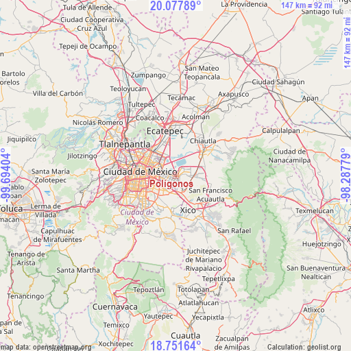
Polígonos GPS coordinates[2]
19° 24' 58.032" North, 98° 59' 27.276" West
| Map corner | latitude | longitude |
|---|---|---|
| Upper-left | 20.07789°, | -99.69404° |
| Center: | 19.41612°, | -98.99091° |
| Lower-right: | 18.75164°, | -98.28779° |
| Map W x H: | 147.5×147.5 km | = 91.7×91.7mi |
| max Lat: | 32.7° ⇑55.9% North |
| Polígonos: | 19.41612° |
| min Lat: | ⇓44.1% South 14.53588° |
| min Long | Polígonos | max Long |
| -117.105° | -98.99091° | -86.73105° |
| W 50.3%⇐ | ⇒49.7% E |
Elevation
Elevation of Polígonos is 2238 m = 7343 ft, and this is 984.3 m = 3229 ft above average elevation for this country.
| Max E: |
3497 m = 11473 ft | 16.2% |
| Polígonos | 2238 m 7343 ft | |
| Avg. | 1253.7 m = 4113 ft | |
Min E: |
-1 m = -3 ft | 83.8% |
See also: Mexico elevation on elevation.city.
Geographical zone
Polígonos is located in North Torrid zone (between Equator and Tropic of Cancer). Distance of this Northern Tropic circle is 447 km =277.8 mi to North.| Distance of | km | miles | from Polígonos |
|---|---|---|---|
| North Pole | 7848.2 | 4876.6 | to North |
| Arctic Circle | 5242.3 | 3257.4 | to North |
| Tropic Cancer | 447 | 277.8 | to North |
| Equator | 2158.9 | 1341.5 | to South |


Nearby cities:
15 places around Polígonos: (largest is in red/bold)
• Arenal
6.4 km =4 mi,  127°
127°
• Ciudad Nezahualcoyotl
3 km =1.9 mi,  235°
235°
• Colonia Gustavo Baz Prada
2.5 km =1.6 mi,  283°
283°
• Lomas de Altavista
7.8 km =4.8 mi,  141°
141°
• Lomas de San Sebastián
7.1 km =4.4 mi,  122°
122°
• Los Reyes Acaquilpan
6 km =3.7 mi,  166°
166°
• Magdalena Atlicpac
6.8 km =4.2 mi, 140°
• Nezahualcóyotl
3.2 km =2 mi,  183°
183°
• Profesor Carlos Hank González
7.3 km =4.5 mi, 131°
• San Sebastián Chimalpa
5.4 km =3.4 mi, 135°
• Santa Martha
7.9 km =4.9 mi,  77°
77°
• Santa María Chimalhuacán
4.3 km =2.7 mi, 81°
• Tecamachalco
7.1 km =4.4 mi,  152°
152°
• Techachaltitla
7.8 km =4.8 mi, 137°
• Unidad Acaquilpan
7.7 km =4.8 mi, 135°
Sources, notices
• [Note1] Compared only with cities in Mexico existing in our database
• [Src1] Map data: © OpenStreetMap contributors (CC-BY-SA)
• [Src2] Other city data from geonames.org with taken over terms of usage.
• [Src3] Geographical zone / Annual Mean Temperature by Robert A. Rohde @ Wikipedia
