Yong Peng geodata
Yong Peng (Johor) is a populated place; located in Malaysia in Asia/Kuala_Lumpur (GMT+8) time zone. With population of 27,138 people, there are 98 cities with bigger population in this country. Compared to other cities in Malaysia, 91% of cities are located further ↑North; 69.1% of cities are located further ←West and 70.8% of cities have higher elevation than Yong Peng. Note1


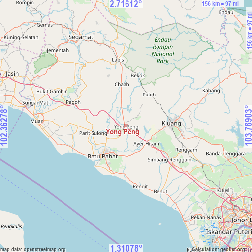
Yong Peng GPS coordinates[2]
2° 0' 48.96" North, 103° 3' 57.24" East
| Map corner | latitude | longitude |
|---|---|---|
| Upper-left | 2.71612°, | 102.36278° |
| Center: | 2.0136°, | 103.0659° |
| Lower-right: | 1.31078°, | 103.76903° |
| Map W x H: | 156.3×156.3 km | = 97.1×97.1mi |
| max Lat: | 6.88732° ⇑91% North |
| Yong Peng: | 2.0136° |
| min Lat: | ⇓9% South 1.24722° |
| min Long | Yong Peng | max Long |
| 99.68252° | 103.0659° | 118.61119° |
| W 69.1%⇐ | ⇒30.9% E |
Elevation
Elevation of Yong Peng is 9 m = 30 ft, and this is 35.7 m = 117 ft below average elevation for this country.
| Max E: |
1488 m = 4882 ft | 70.8% |
| Avg. | 44.7 m = 147 ft | |
| Yong Peng | 9 m = 30 ft | |
Min E: |
0 m = 0 ft | 29.2% |
See also: Malaysia elevation on elevation.city.
Geographical zone
Yong Peng is located in North Torrid zone (between Equator and Tropic of Cancer). Distance of Equator is 223.9 km =139.1 mi to South.| Distance of | km | miles | from Yong Peng |
|---|---|---|---|
| North Pole | 9783.2 | 6079 | to North |
| Arctic Circle | 7177.3 | 4459.8 | to North |
| Tropic Cancer | 2382 | 1480.1 | to North |
| Equator | 223.9 | 139.1 | to South |


Nearby cities:
15 places around Yong Peng: (largest is in red/bold)
• Bakri
46 km =28.6 mi,  274°
274°
• Batu Pahat
23.1 km =14.4 mi,  220°
220°
• Buloh Kasap
68.8 km =42.8 mi,  330°
330°
• Chaah
26.2 km =16.3 mi,  355°
355°
• Kampung Simpang Renggam
33.2 km =20.6 mi,  128°
128°
• Kelapa Sawit
64.4 km =40 mi, 126°
• Kluang
28 km =17.4 mi,  86°
86°
• Kulai
71.7 km =44.6 mi,  123°
123°
• Labis
41.6 km =25.8 mi,  353°
353°
• Muar
55.3 km =34.4 mi, 273°
• Parit Raja
17 km =10.6 mi,  162°
162°
• Pekan Nenas
74.9 km =46.5 mi,  138°
138°
• Pontian Kechil
68.8 km =42.8 mi,  148°
148°
• Segamat
62.3 km =38.7 mi, 333°
• Tangkak
64.4 km =40 mi,  295°
295°
Sources, notices
• [Note1] Compared only with cities in Malaysia existing in our database
• [Src1] Map data: © OpenStreetMap contributors (CC-BY-SA)
• [Src2] Other city data from geonames.org with taken over terms of usage.
• [Src3] Geographical zone / Annual Mean Temperature by Robert A. Rohde @ Wikipedia
