Batang Berjuntai geodata
Batang Berjuntai (Selangor) is a populated place; located in Malaysia in Asia/Kuala_Lumpur (GMT+8) time zone. With population of 20,001 people, there are 118 cities with bigger population in this country. Compared to other cities in Malaysia, 55.6% of cities are located further ↑North; 70.2% of cities are located further →East and 76.4% of cities have lower elevation than Batang Berjuntai. Note1


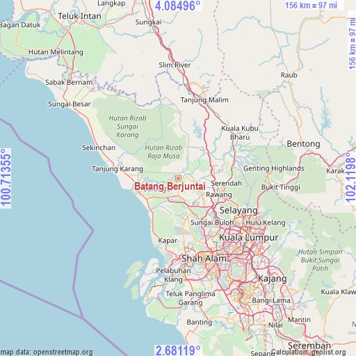
Batang Berjuntai GPS coordinates[2]
3° 22' 59.988" North, 101° 25' 0.012" East
| Map corner | latitude | longitude |
|---|---|---|
| Upper-left | 4.08496°, | 100.71355° |
| Center: | 3.38333°, | 101.41667° |
| Lower-right: | 2.68119°, | 102.1198° |
| Map W x H: | 156.1×156.1 km | = 97×97mi |
| max Lat: | 6.88732° ⇑55.6% North |
| Batang Berjuntai: | 3.38333° |
| min Lat: | ⇓44.4% South 1.24722° |
| min Long | Batang Berjunta | max Long |
| 99.68252° | 101.41667° | 118.61119° |
| W 29.8%⇐ | ⇒70.2% E |
Elevation
Elevation of Batang Berjuntai is 35 m = 115 ft, and this is 9.7 m = 32 ft below average elevation for this country.
| Max E: |
1488 m = 4882 ft | 23.6% |
| Avg. | 44.7 m = 147 ft | |
| Batang Berjuntai | 35 m = 115 ft | |
Min E: |
0 m = 0 ft | 76.4% |
See also: Malaysia elevation on elevation.city.
Geographical zone
Batang Berjuntai is located in North Torrid zone (between Equator and Tropic of Cancer). Distance of Equator is 376.2 km =233.8 mi to South.| Distance of | km | miles | from Batang Berjuntai |
|---|---|---|---|
| North Pole | 9630.9 | 5984.4 | to North |
| Arctic Circle | 7025 | 4365.1 | to North |
| Tropic Cancer | 2229.7 | 1385.5 | to North |
| Equator | 376.2 | 233.8 | to South |


Nearby cities:
15 places around Batang Berjuntai: (largest is in red/bold)
• Batu Arang
9.3 km =5.8 mi,  143°
143°
• Kampong Dungun
21.6 km =13.4 mi,  210°
210°
• Kampung Baru Subang
29 km =18 mi,  153°
153°
• Kampung Tanjung Karang
26.1 km =16.2 mi,  280°
280°
• Klang
38.7 km =24 mi,  175°
175°
• Kuala Lumpur
40.3 km =25 mi,  131°
131°
• Kuala Selangor
18.9 km =11.7 mi,  258°
258°
• Kuang
20.6 km =12.8 mi, 132°
• Ladang Seri Kundang
15.7 km =9.8 mi, 133°
• Pelabuhan Klang
42.7 km =26.5 mi, 183°
• Petaling Jaya
37.2 km =23.1 mi, 145°
• Rawang
19.1 km =11.9 mi,  111°
111°
• Serendah
20.9 km =13 mi,  95°
95°
• Shah Alam
35.6 km =22.1 mi,  158°
158°
• Subang Jaya
41.9 km =26 mi, 154°
Sources, notices
• [Note1] Compared only with cities in Malaysia existing in our database
• [Src1] Map data: © OpenStreetMap contributors (CC-BY-SA)
• [Src2] Other city data from geonames.org with taken over terms of usage.
• [Src3] Geographical zone / Annual Mean Temperature by Robert A. Rohde @ Wikipedia
