Serendah geodata
Serendah (Selangor) is a populated place; located in Malaysia in Asia/Kuala_Lumpur (GMT+8) time zone. With population of 28,484 people, there are 92 cities with bigger population in this country. Compared to other cities in Malaysia, 56.2% of cities are located further ↑North; 62.9% of cities are located further →East and 81.5% of cities have lower elevation than Serendah. Note1


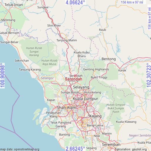
Serendah GPS coordinates[2]
3° 21' 52.56" North, 101° 36' 14.76" East
| Map corner | latitude | longitude |
|---|---|---|
| Upper-left | 4.06624°, | 100.90098° |
| Center: | 3.3646°, | 101.6041° |
| Lower-right: | 2.66245°, | 102.30723° |
| Map W x H: | 156.1×156.1 km | = 97×97mi |
| max Lat: | 6.88732° ⇑56.2% North |
| Serendah: | 3.3646° |
| min Lat: | ⇓43.8% South 1.24722° |
| min Long | Serendah | max Long |
| 99.68252° | 101.6041° | 118.61119° |
| W 37.1%⇐ | ⇒62.9% E |
Elevation
Elevation of Serendah is 42 m = 138 ft, and this is 2.7 m = 9 ft below average elevation for this country.
| Max E: |
1488 m = 4882 ft | 18.5% |
| Avg. | 44.7 m = 147 ft | |
| Serendah | 42 m = 138 ft | |
Min E: |
0 m = 0 ft | 81.5% |
See also: Malaysia elevation on elevation.city.
Geographical zone
Serendah is located in North Torrid zone (between Equator and Tropic of Cancer). Distance of Equator is 374.1 km =232.5 mi to South.| Distance of | km | miles | from Serendah |
|---|---|---|---|
| North Pole | 9633 | 5985.7 | to North |
| Arctic Circle | 7027.1 | 4366.4 | to North |
| Tropic Cancer | 2231.8 | 1386.8 | to North |
| Equator | 374.1 | 232.5 | to South |


Nearby cities:
15 places around Serendah: (largest is in red/bold)
• Ampang
29.9 km =18.6 mi,  142°
142°
• Batang Berjuntai
20.9 km =13 mi,  275°
275°
• Batu Arang
16.2 km =10.1 mi,  250°
250°
• Bentong Town
38.1 km =23.7 mi,  62°
62°
• Kampong Dungun
35.9 km =22.3 mi,  242°
242°
• Kampung Baru Subang
25.1 km =15.6 mi,  198°
198°
• Kampung Bukit Tinggi, Bentong
24.7 km =15.3 mi,  93°
93°
• Kuala Lumpur
26.5 km =16.5 mi,  159°
159°
• Kuala Selangor
39.3 km =24.4 mi,  267°
267°
• Kuang
12.9 km =8 mi,  205°
205°
• Ladang Seri Kundang
12.9 km =8 mi,  227°
227°
• Petaling Jaya
28.6 km =17.8 mi,  179°
179°
• Rawang
5.7 km =3.5 mi, 212°
• Shah Alam
32.1 km =19.9 mi,  194°
194°
• Subang Jaya
35.8 km =22.2 mi, 184°
Sources, notices
• [Note1] Compared only with cities in Malaysia existing in our database
• [Src1] Map data: © OpenStreetMap contributors (CC-BY-SA)
• [Src2] Other city data from geonames.org with taken over terms of usage.
• [Src3] Geographical zone / Annual Mean Temperature by Robert A. Rohde @ Wikipedia
