Rawang geodata
Rawang (Selangor) is a populated place; located in Malaysia in Asia/Kuala_Lumpur (GMT+8) time zone. With population of 120,447 people, there are 35 cities with bigger population in this country. Compared to other cities in Malaysia, 57.9% of cities are located further ↑North; 64% of cities are located further →East and 78.1% of cities have lower elevation than Rawang. Note1


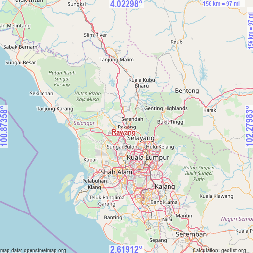
Rawang GPS coordinates[2]
3° 19' 16.68" North, 101° 34' 36.12" East
| Map corner | latitude | longitude |
|---|---|---|
| Upper-left | 4.02298°, | 100.87358° |
| Center: | 3.3213°, | 101.5767° |
| Lower-right: | 2.61912°, | 102.27983° |
| Map W x H: | 156.1×156.1 km | = 97×97mi |
| max Lat: | 6.88732° ⇑57.9% North |
| Rawang: | 3.3213° |
| min Lat: | ⇓42.1% South 1.24722° |
| min Long | Rawang | max Long |
| 99.68252° | 101.5767° | 118.61119° |
| W 36%⇐ | ⇒64% E |
Elevation
Elevation of Rawang is 38 m = 125 ft, and this is 6.7 m = 22 ft below average elevation for this country.
| Max E: |
1488 m = 4882 ft | 21.9% |
| Avg. | 44.7 m = 147 ft | |
| Rawang | 38 m = 125 ft | |
Min E: |
0 m = 0 ft | 78.1% |
See also: Rawang elevation on elevation.city.
Geographical zone
Rawang is located in North Torrid zone (between Equator and Tropic of Cancer). Distance of Equator is 369.3 km =229.5 mi to South.| Distance of | km | miles | from Rawang |
|---|---|---|---|
| North Pole | 9637.8 | 5988.6 | to North |
| Arctic Circle | 7031.9 | 4369.4 | to North |
| Tropic Cancer | 2236.6 | 1389.8 | to North |
| Equator | 369.3 | 229.5 | to South |


Nearby cities:
15 places around Rawang: (largest is in red/bold)
• Ampang
28.4 km =17.6 mi,  132°
132°
• Batang Berjuntai
19.1 km =11.9 mi,  291°
291°
• Batu Arang
12.2 km =7.6 mi,  267°
267°
• Kampong Dungun
31.1 km =19.3 mi,  248°
248°
• Kampung Baru Subang
19.6 km =12.2 mi,  194°
194°
• Kampung Bukit Tinggi, Bentong
27.9 km =17.3 mi,  83°
83°
• Klang
34.9 km =21.7 mi,  205°
205°
• Kuala Lumpur
23.4 km =14.5 mi,  148°
148°
• Kuang
7.3 km =4.5 mi,  200°
200°
• Ladang Seri Kundang
7.5 km =4.7 mi,  238°
238°
• Petaling Jaya
24 km =14.9 mi,  172°
172°
• Putra Heights
36.4 km =22.6 mi,  180°
180°
• Serendah
5.7 km =3.5 mi,  32°
32°
• Shah Alam
26.7 km =16.6 mi, 190°
• Subang Jaya
30.9 km =19.2 mi, 179°
Sources, notices
• [Note1] Compared only with cities in Malaysia existing in our database
• [Src1] Map data: © OpenStreetMap contributors (CC-BY-SA)
• [Src2] Other city data from geonames.org with taken over terms of usage.
• [Src3] Geographical zone / Annual Mean Temperature by Robert A. Rohde @ Wikipedia
