Xai-Xai geodata
Xai-Xai (Gaza) is a seat of a first-order administrative division; located in Mozambique in Africa/Maputo (GMT+2) time zone. With population of 127,366 people, there are 8 cities with bigger population in this country. Compared to other cities in Mozambique, 84.6% of cities are located further ↑North; 65.4% of cities are located further →East and 100% of cities have higher elevation than Xai-Xai. Note1


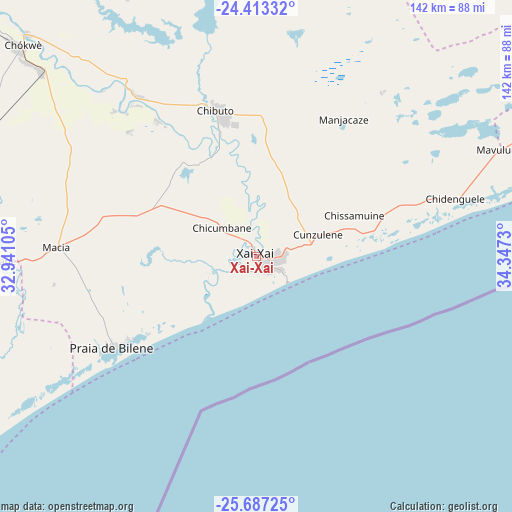
Xai-Xai GPS coordinates[2]
25° 3' 6.984" South, 33° 38' 39.012" East
| Map corner | latitude | longitude |
|---|---|---|
| Upper-left | -24.41332°, | 32.94105° |
| Center: | -25.05194°, | 33.64417° |
| Lower-right: | -25.68725°, | 34.3473° |
| Map W x H: | 141.6×141.6 km | = 88×88mi |
| max Lat: | -11.31667° ⇑84.6% North |
| Xai-Xai: | -25.05194° |
| min Lat: | ⇓15.4% South -25.96553° |
| min Long | Xai-Xai | max Long |
| 31.99528° | 33.64417° | 40.73583° |
| W 34.6%⇐ | ⇒65.4% E |
Elevation
Elevation of Xai-Xai is 4 m = 13 ft, and this is 215.5 m = 707 ft below average elevation for this country.
| Max E: |
1349 m = 4426 ft | 100% |
| Avg. | 219.5 m = 720 ft | |
| Xai-Xai | 4 m = 13 ft | |
Min E: |
4 m = 13 ft | 0% |
See also: Xai-Xai elevation on elevation.city.
Geographical zone
Xai-Xai is located in South temperate zone (between Tropic of Capricorn and the Antarctic Circle). Distance of this Southern Tropic circle is 179.6 km =111.6 mi to North.| Distance of | km | miles | from Xai-Xai |
|---|---|---|---|
| Equator | 2785.5 | 1730.8 | to North |
| Tropic Capricorn | 179.6 | 111.6 | to North |
| Antarctic Circle | 4615.7 | 2868.1 | to South |
| South Pole | 7221.5 | 4487.2 | to South |


Nearby cities:
9 places around Xai-Xai: (largest is in red/bold)
• Chibuto
42.2 km =26.2 mi,  344°
344°
• Chokwé
88.2 km =54.8 mi,  310°
310°
• Inhambane
220 km =136.7 mi,  53°
53°
• Macia
55 km =34.2 mi,  272°
272°
• Manhiça
92.8 km =57.7 mi,  245°
245°
• Maputo
147.2 km =91.5 mi,  226°
226°
• Matola
156.2 km =97.1 mi, 229°
• Maxixe
217.4 km =135.1 mi, 52°
• Ressano Garcia
171.4 km =106.5 mi,  255°
255°
Sources, notices
• [Note1] Compared only with cities in Mozambique existing in our database
• [Src1] Map data: © OpenStreetMap contributors (CC-BY-SA)
• [Src2] Other city data from geonames.org with taken over terms of usage.
• [Src3] Geographical zone / Annual Mean Temperature by Robert A. Rohde @ Wikipedia
