Manhiça geodata
Manhiça (Maputo) is a seat of a second-order administrative division; located in Mozambique in Africa/Maputo (GMT+2) time zone. In our database, there are 26 cities with bigger population. Compared to other cities in Mozambique, 88.5% of cities are located further ↑North; 88.5% of cities are located further →East and 61.5% of cities have higher elevation than Manhiça. Note1


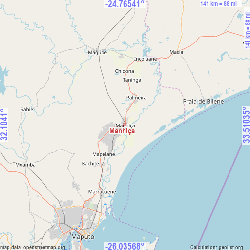
Manhiça GPS coordinates[2]
25° 24' 7.992" South, 32° 48' 25.992" East
| Map corner | latitude | longitude |
|---|---|---|
| Upper-left | -24.76541°, | 32.1041° |
| Center: | -25.40222°, | 32.80722° |
| Lower-right: | -26.03568°, | 33.51035° |
| Map W x H: | 141.2×141.2 km | = 87.7×87.7mi |
| max Lat: | -11.31667° ⇑88.5% North |
| Manhiça: | -25.40222° |
| min Lat: | ⇓11.5% South -25.96553° |
| min Long | Manhiça | max Long |
| 31.99528° | 32.80722° | 40.73583° |
| W 11.5%⇐ | ⇒88.5% E |
Elevation
Elevation of Manhiça is 41 m = 135 ft, and this is 178.5 m = 586 ft below average elevation for this country.
| Max E: |
1349 m = 4426 ft | 61.5% |
| Avg. | 219.5 m = 720 ft | |
| Manhiça | 41 m = 135 ft | |
Min E: |
4 m = 13 ft | 38.5% |
See also: Mozambique elevation on elevation.city.
Geographical zone
Manhiça is located in South temperate zone (between Tropic of Capricorn and the Antarctic Circle). Distance of this Southern Tropic circle is 218.5 km =135.8 mi to North.| Distance of | km | miles | from Manhiça |
|---|---|---|---|
| Equator | 2824.5 | 1755.1 | to North |
| Tropic Capricorn | 218.5 | 135.8 | to North |
| Antarctic Circle | 4576.7 | 2843.8 | to South |
| South Pole | 7182.6 | 4463.1 | to South |


Nearby cities:
9 places around Manhiça: (largest is in red/bold)
• Chibuto
107.9 km =67 mi,  42°
42°
• Chokwé
98.2 km =61 mi,  10°
10°
• Inhambane
311.4 km =193.5 mi,  56°
56°
• Macia
51 km =31.7 mi, 35°
• Maputo
66.5 km =41.3 mi,  199°
199°
• Matola
71.4 km =44.4 mi,  209°
209°
• Maxixe
308.7 km =191.8 mi, 56°
• Ressano Garcia
81.7 km =50.8 mi,  266°
266°
• Xai-Xai
92.8 km =57.7 mi,  65°
65°
Sources, notices
• [Note1] Compared only with cities in Mozambique existing in our database
• [Src1] Map data: © OpenStreetMap contributors (CC-BY-SA)
• [Src2] Other city data from geonames.org with taken over terms of usage.
• [Src3] Geographical zone / Annual Mean Temperature by Robert A. Rohde @ Wikipedia
