Chibuto geodata
Chibuto (Gaza) is a populated place; located in Mozambique in Africa/Maputo (GMT+2) time zone. With population of 59,165 people, there are 20 cities with bigger population in this country. Compared to other cities in Mozambique, 76.9% of cities are located further ↑North; 73.1% of cities are located further →East and 61.5% of cities have lower elevation than Chibuto. Note1


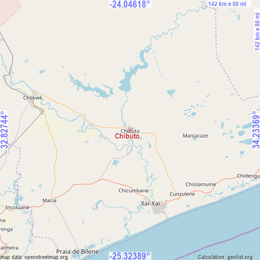
Chibuto GPS coordinates[2]
24° 41' 12.012" South, 33° 31' 50.016" East
| Map corner | latitude | longitude |
|---|---|---|
| Upper-left | -24.04618°, | 32.82744° |
| Center: | -24.68667°, | 33.53056° |
| Lower-right: | -25.32389°, | 34.23369° |
| Map W x H: | 142.1×142.1 km | = 88.3×88.3mi |
| max Lat: | -11.31667° ⇑76.9% North |
| Chibuto: | -24.68667° |
| min Lat: | ⇓23.1% South -25.96553° |
| min Long | Chibuto | max Long |
| 31.99528° | 33.53056° | 40.73583° |
| W 26.9%⇐ | ⇒73.1% E |
Elevation
Elevation of Chibuto is 105 m = 344 ft, and this is 114.5 m = 376 ft below average elevation for this country.
| Max E: |
1349 m = 4426 ft | 38.5% |
| Avg. | 219.5 m = 720 ft | |
| Chibuto | 105 m = 344 ft | |
Min E: |
4 m = 13 ft | 61.5% |
See also: Chibuto elevation on elevation.city.
Geographical zone
Chibuto is located in South temperate zone (between Tropic of Capricorn and the Antarctic Circle). Distance of this Southern Tropic circle is 139 km =86.4 mi to North.| Distance of | km | miles | from Chibuto |
|---|---|---|---|
| Equator | 2744.9 | 1705.6 | to North |
| Tropic Capricorn | 139 | 86.4 | to North |
| Antarctic Circle | 4656.3 | 2893.3 | to South |
| South Pole | 7262.2 | 4512.5 | to South |


Nearby cities:
9 places around Chibuto: (largest is in red/bold)
• Chokwé
57.9 km =36 mi,  287°
287°
• Inhambane
208.8 km =129.7 mi,  64°
64°
• Macia
57.7 km =35.9 mi,  229°
229°
• Manhiça
107.9 km =67 mi,  222°
222°
• Maputo
171.1 km =106.3 mi,  213°
213°
• Matola
178.1 km =110.7 mi, 217°
• Maxixe
205.8 km =127.9 mi, 63°
• Ressano Garcia
176 km =109.4 mi,  241°
241°
• Xai-Xai
42.2 km =26.2 mi,  164°
164°
Sources, notices
• [Note1] Compared only with cities in Mozambique existing in our database
• [Src1] Map data: © OpenStreetMap contributors (CC-BY-SA)
• [Src2] Other city data from geonames.org with taken over terms of usage.
• [Src3] Geographical zone / Annual Mean Temperature by Robert A. Rohde @ Wikipedia
