Pemba geodata
Pemba (Cabo Delgado) is a seat of a first-order administrative division; located in Mozambique in Africa/Maputo (GMT+2) time zone. With population of 108,737 people, there are 13 cities with bigger population in this country. Compared to other cities in Mozambique, 96.2% of cities are located further ↓South; 92.3% of cities are located further ←West and 53.8% of cities have higher elevation than Pemba. Note1


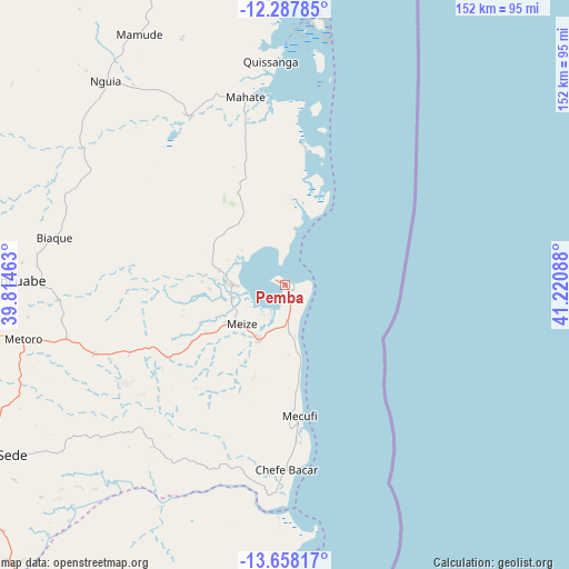
Pemba GPS coordinates[2]
12° 58' 26.22" South, 40° 31' 3.9" East
| Map corner | latitude | longitude |
|---|---|---|
| Upper-left | -12.28785°, | 39.81463° |
| Center: | -12.97395°, | 40.51775° |
| Lower-right: | -13.65817°, | 41.22088° |
| Map W x H: | 152.4×152.4 km | = 94.7×94.7mi |
| max Lat: | -11.31667° ⇑3.8% North |
| Pemba: | -12.97395° |
| min Lat: | ⇓96.2% South -25.96553° |
| min Long | Pemba | max Long |
| 31.99528° | 40.51775° | 40.73583° |
| W 92.3%⇐ | ⇒7.7% E |
Elevation
Elevation of Pemba is 50 m = 164 ft, and this is 169.5 m = 556 ft below average elevation for this country.
| Max E: |
1349 m = 4426 ft | 53.8% |
| Avg. | 219.5 m = 720 ft | |
| Pemba | 50 m = 164 ft | |
Min E: |
4 m = 13 ft | 46.2% |
See also: Pemba elevation on elevation.city.
Geographical zone
Pemba is located in South Torrid zone (between Equator and Tropic of Capricorn). Distance of this Southern Tropic circle is 1163.4 km =722.9 mi to South.| Distance of | km | miles | from Pemba |
|---|---|---|---|
| Equator | 1442.6 | 896.4 | to North |
| Tropic Capricorn | 1163.4 | 722.9 | to South |
| Antarctic Circle | 5958.6 | 3702.5 | to South |
| South Pole | 8564.5 | 5321.7 | to South |


Nearby cities:
7 places around Pemba: (largest is in red/bold)
• António Enes
368.2 km =228.8 mi,  190°
190°
• Ilha de Moçambique
230.3 km =143.1 mi,  174°
174°
• Mocímboa
185.2 km =115.1 mi,  354°
354°
• Montepuez
165.3 km =102.7 mi,  264°
264°
• Mutuáli
433.8 km =269.6 mi,  240°
240°
• Nacala
177.6 km =110.4 mi, 174°
• Nampula
273.8 km =170.1 mi,  209°
209°
Sources, notices
• [Note1] Compared only with cities in Mozambique existing in our database
• [Src1] Map data: © OpenStreetMap contributors (CC-BY-SA)
• [Src2] Other city data from geonames.org with taken over terms of usage.
• [Src3] Geographical zone / Annual Mean Temperature by Robert A. Rohde @ Wikipedia
