António Enes geodata
António Enes (Nampula) is a populated place; located in Mozambique in Africa/Maputo (GMT+2) time zone. With population of 74,624 people, there are 15 cities with bigger population in this country. Compared to other cities in Mozambique, 57.7% of cities are located further ↓South; 84.6% of cities are located further ←West and 76.9% of cities have higher elevation than António Enes. Note1


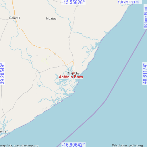
António Enes GPS coordinates[2]
16° 13' 57" South, 39° 54' 30.996" East
| Map corner | latitude | longitude |
|---|---|---|
| Upper-left | -15.55626°, | 39.20549° |
| Center: | -16.2325°, | 39.90861° |
| Lower-right: | -16.90642°, | 40.61174° |
| Map W x H: | 150.1×150.1 km | = 93.3×93.3mi |
| max Lat: | -11.31667° ⇑42.3% North |
| António Enes: | -16.2325° |
| min Lat: | ⇓57.7% South -25.96553° |
| min Long | António Enes | max Long |
| 31.99528° | 39.90861° | 40.73583° |
| W 84.6%⇐ | ⇒15.4% E |
Elevation
Elevation of António Enes is 12 m = 39 ft, and this is 207.5 m = 681 ft below average elevation for this country.
| Max E: |
1349 m = 4426 ft | 76.9% |
| Avg. | 219.5 m = 720 ft | |
| António Enes | 12 m = 39 ft | |
Min E: |
4 m = 13 ft | 23.1% |
See also: António Enes elevation on elevation.city.
Geographical zone
António Enes is located in South Torrid zone (between Equator and Tropic of Capricorn). Distance of this Southern Tropic circle is 801 km =497.7 mi to South.| Distance of | km | miles | from António Enes |
|---|---|---|---|
| Equator | 1804.9 | 1121.5 | to North |
| Tropic Capricorn | 801 | 497.7 | to South |
| Antarctic Circle | 5596.3 | 3477.4 | to South |
| South Pole | 8202.2 | 5096.6 | to South |


Nearby cities:
8 places around António Enes: (largest is in red/bold)
• Cuamba
394.6 km =245.2 mi,  293°
293°
• Ilha de Moçambique
160 km =99.4 mi,  33°
33°
• Montepuez
359 km =223.1 mi,  344°
344°
• Mutuáli
346 km =215 mi,  295°
295°
• Nacala
203.5 km =126.4 mi,  24°
24°
• Nampula
141.9 km =88.2 mi,  331°
331°
• Pemba
368.2 km =228.8 mi,  10°
10°
• Quelimane
369.5 km =229.6 mi,  240°
240°
Sources, notices
• [Note1] Compared only with cities in Mozambique existing in our database
• [Src1] Map data: © OpenStreetMap contributors (CC-BY-SA)
• [Src2] Other city data from geonames.org with taken over terms of usage.
• [Src3] Geographical zone / Annual Mean Temperature by Robert A. Rohde @ Wikipedia
