Nampula geodata
Nampula is a seat of a first-order administrative division; located in Mozambique in Africa/Maputo (GMT+2) time zone. With population of 388,526 people, there are 3 cities with bigger population in this country. Compared to other cities in Mozambique, 65.4% of cities are located further ↓South; 80.8% of cities are located further ←West and 76.9% of cities have lower elevation than Nampula. Note1


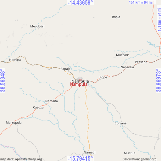
Nampula GPS coordinates[2]
15° 6' 59.256" South, 39° 15' 59.76" East
| Map corner | latitude | longitude |
|---|---|---|
| Upper-left | -14.43659°, | 38.56348° |
| Center: | -15.11646°, | 39.2666° |
| Lower-right: | -15.79415°, | 39.96973° |
| Map W x H: | 150.9×150.9 km | = 93.8×93.8mi |
| max Lat: | -11.31667° ⇑34.6% North |
| Nampula: | -15.11646° |
| min Lat: | ⇓65.4% South -25.96553° |
| min Long | Nampula | max Long |
| 31.99528° | 39.2666° | 40.73583° |
| W 80.8%⇐ | ⇒19.2% E |
Elevation
Elevation of Nampula is 431 m = 1414 ft, and this is 211.5 m = 694 ft above average elevation for this country.
| Max E: |
1349 m = 4426 ft | 23.1% |
| Nampula | 431 m 1414 ft | |
| Avg. | 219.5 m = 720 ft | |
Min E: |
4 m = 13 ft | 76.9% |
See also: Nampula elevation on elevation.city.
Geographical zone
Nampula is located in South Torrid zone (between Equator and Tropic of Capricorn). Distance of this Southern Tropic circle is 925.1 km =574.8 mi to South.| Distance of | km | miles | from Nampula |
|---|---|---|---|
| Equator | 1680.8 | 1044.4 | to North |
| Tropic Capricorn | 925.1 | 574.8 | to South |
| Antarctic Circle | 5720.4 | 3554.5 | to South |
| South Pole | 8326.3 | 5173.7 | to South |


Nearby cities:
10 places around Nampula: (largest is in red/bold)
• António Enes
141.9 km =88.2 mi,  151°
151°
• Cuamba
295.3 km =183.5 mi,  276°
276°
• Ilha de Moçambique
158 km =98.2 mi,  86°
86°
• Mandimba
398 km =247.3 mi, 282°
• Mocímboa
438.5 km =272.5 mi,  15°
15°
• Montepuez
223.2 km =138.7 mi,  352°
352°
• Mutuáli
244.5 km =151.9 mi, 276°
• Nacala
164.5 km =102.2 mi,  68°
68°
• Pemba
273.8 km =170.1 mi,  29°
29°
• Quelimane
398.2 km =247.4 mi,  219°
219°
Sources, notices
• [Note1] Compared only with cities in Mozambique existing in our database
• [Src1] Map data: © OpenStreetMap contributors (CC-BY-SA)
• [Src2] Other city data from geonames.org with taken over terms of usage.
• [Src3] Geographical zone / Annual Mean Temperature by Robert A. Rohde @ Wikipedia
