Ngo geodata
Ngo (Rivers) is a seat of a second-order administrative division; located in Nigeria in Africa/Lagos (GMT+1) time zone. In our database, there are 451 cities with bigger population. Compared to other cities in Nigeria, 99.8% of cities are located further ↑North; 51.9% of cities are located further ←West and 98.5% of cities have higher elevation than Ngo. Note1


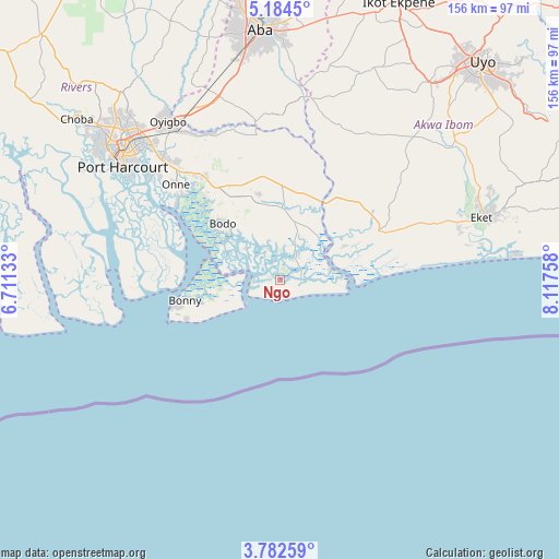
Ngo GPS coordinates[2]
4° 29' 1.968" North, 7° 24' 52.056" East
| Map corner | latitude | longitude |
|---|---|---|
| Upper-left | 5.1845°, | 6.71133° |
| Center: | 4.48388°, | 7.41446° |
| Lower-right: | 3.78259°, | 8.11758° |
| Map W x H: | 155.9×155.9 km | = 96.9×96.9mi |
| max Lat: | 13.7543° ⇑99.8% North |
| Ngo: | 4.48388° |
| min Lat: | ⇓0.2% South 4.31231° |
| min Long | Ngo | max Long |
| 2.73333° | 7.41446° | 14.46552° |
| W 51.9%⇐ | ⇒48.1% E |
Elevation
Elevation of Ngo is 7 m = 23 ft, and this is 289.5 m = 950 ft below average elevation for this country.
| Max E: |
1599 m = 5246 ft | 98.5% |
| Avg. | 296.5 m = 973 ft | |
| Ngo | 7 m = 23 ft | |
Min E: |
2 m = 7 ft | 1.5% |
See also: Nigeria elevation on elevation.city.
Geographical zone
Ngo is located in North Torrid zone (between Equator and Tropic of Cancer). Distance of Equator is 498.6 km =309.8 mi to South.| Distance of | km | miles | from Ngo |
|---|---|---|---|
| North Pole | 9508.5 | 5908.3 | to North |
| Arctic Circle | 6902.6 | 4289.1 | to North |
| Tropic Cancer | 2107.4 | 1309.5 | to North |
| Equator | 498.6 | 309.8 | to South |


Nearby cities:
15 places around Ngo: (largest is in red/bold)
• Afam
35.9 km =22.3 mi,  341°
341°
• Akwete
45.3 km =28.1 mi,  351°
351°
• Bonny
27.3 km =17 mi,  262°
262°
• Bori
22.1 km =13.7 mi, 345°
• Ikot Abasi
18 km =11.2 mi,  58°
58°
• Ikot Akpa Nkuk
46.3 km =28.8 mi,  21°
21°
• Ikot Ibritam
42.6 km =26.5 mi,  31°
31°
• Kpor
23.7 km =14.7 mi,  322°
322°
• Mkpat Enin
46.4 km =28.8 mi,  53°
53°
• Nchia
47.4 km =29.5 mi, 316°
• Ogu
35.7 km =22.2 mi, 317°
• Okoroete
37.6 km =23.4 mi,  80°
80°
• Okrika
46.6 km =29 mi,  308°
308°
• Opobo
14.1 km =8.8 mi, 76°
• Saakpenwa
30.9 km =19.2 mi,  327°
327°
Sources, notices
• [Note1] Compared only with cities in Nigeria existing in our database
• [Src1] Map data: © OpenStreetMap contributors (CC-BY-SA)
• [Src2] Other city data from geonames.org with taken over terms of usage.
• [Src3] Geographical zone / Annual Mean Temperature by Robert A. Rohde @ Wikipedia
