Saakpenwa geodata
Saakpenwa (Rivers) is a seat of a second-order administrative division; located in Nigeria in Africa/Lagos (GMT+1) time zone. In our database, there are 451 cities with bigger population. Compared to other cities in Nigeria, 98.2% of cities are located further ↑North; 51.3% of cities are located further →East and 91.6% of cities have higher elevation than Saakpenwa. Note1


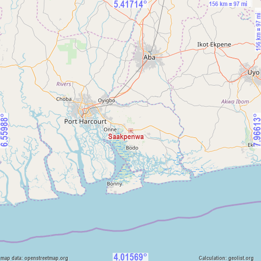
Saakpenwa GPS coordinates[2]
4° 43' 0.372" North, 7° 15' 46.8" East
| Map corner | latitude | longitude |
|---|---|---|
| Upper-left | 5.41714°, | 6.55988° |
| Center: | 4.71677°, | 7.263° |
| Lower-right: | 4.01569°, | 7.96613° |
| Map W x H: | 155.8×155.8 km | = 96.8×96.8mi |
| max Lat: | 13.7543° ⇑98.2% North |
| Saakpenwa: | 4.71677° |
| min Lat: | ⇓1.8% South 4.31231° |
| min Long | Saakpenwa | max Long |
| 2.73333° | 7.263° | 14.46552° |
| W 48.7%⇐ | ⇒51.3% E |
Elevation
Elevation of Saakpenwa is 23 m = 75 ft, and this is 273.5 m = 897 ft below average elevation for this country.
| Max E: |
1599 m = 5246 ft | 91.6% |
| Avg. | 296.5 m = 973 ft | |
| Saakpenwa | 23 m = 75 ft | |
Min E: |
2 m = 7 ft | 8.4% |
See also: Nigeria elevation on elevation.city.
Geographical zone
Saakpenwa is located in North Torrid zone (between Equator and Tropic of Cancer). Distance of Equator is 524.5 km =325.9 mi to South.| Distance of | km | miles | from Saakpenwa |
|---|---|---|---|
| North Pole | 9482.6 | 5892.2 | to North |
| Arctic Circle | 6876.7 | 4273 | to North |
| Tropic Cancer | 2081.5 | 1293.4 | to North |
| Equator | 524.5 | 325.9 | to South |


Nearby cities:
15 places around Saakpenwa: (largest is in red/bold)
• Afam
9.8 km =6.1 mi,  33°
33°
• Akwete
21.6 km =13.4 mi, 28°
• Bonny
31.2 km =19.4 mi,  199°
199°
• Bori
12.2 km =7.6 mi,  111°
111°
• Ikot Abasi
36.1 km =22.4 mi,  117°
117°
• Ikot Akpa Nkuk
37.6 km =23.4 mi,  62°
62°
• Kpor
7.5 km =4.7 mi,  161°
161°
• Nchia
17.9 km =11.1 mi,  298°
298°
• Ngo
30.9 km =19.2 mi,  147°
147°
• Ogu
7.2 km =4.5 mi,  275°
275°
• Oke-Ikpe
22.7 km =14.1 mi,  15°
15°
• Okrika
20.1 km =12.5 mi, 278°
• Opobo
37.9 km =23.5 mi,  126°
126°
• Port Harcourt
28.5 km =17.7 mi, 283°
• Rumuodomaya
34.9 km =21.7 mi, 304°
Sources, notices
• [Note1] Compared only with cities in Nigeria existing in our database
• [Src1] Map data: © OpenStreetMap contributors (CC-BY-SA)
• [Src2] Other city data from geonames.org with taken over terms of usage.
• [Src3] Geographical zone / Annual Mean Temperature by Robert A. Rohde @ Wikipedia
