Okoroete geodata
Okoroete (Akwa Ibom) is a seat of a second-order administrative division; located in Nigeria in Africa/Lagos (GMT+1) time zone. In our database, there are 451 cities with bigger population. Compared to other cities in Nigeria, 99.4% of cities are located further ↑North; 58.8% of cities are located further ←West and 94.9% of cities have higher elevation than Okoroete. Note1


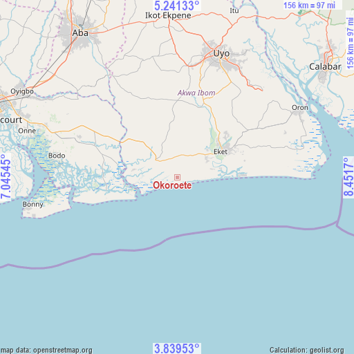
Okoroete GPS coordinates[2]
4° 32' 26.772" North, 7° 44' 54.888" East
| Map corner | latitude | longitude |
|---|---|---|
| Upper-left | 5.24133°, | 7.04545° |
| Center: | 4.54077°, | 7.74858° |
| Lower-right: | 3.83953°, | 8.4517° |
| Map W x H: | 155.9×155.9 km | = 96.9×96.9mi |
| max Lat: | 13.7543° ⇑99.4% North |
| Okoroete: | 4.54077° |
| min Lat: | ⇓0.6% South 4.31231° |
| min Long | Okoroete | max Long |
| 2.73333° | 7.74858° | 14.46552° |
| W 58.8%⇐ | ⇒41.2% E |
Elevation
Elevation of Okoroete is 12 m = 39 ft, and this is 284.5 m = 933 ft below average elevation for this country.
| Max E: |
1599 m = 5246 ft | 94.9% |
| Avg. | 296.5 m = 973 ft | |
| Okoroete | 12 m = 39 ft | |
Min E: |
2 m = 7 ft | 5.1% |
See also: Nigeria elevation on elevation.city.
Geographical zone
Okoroete is located in North Torrid zone (between Equator and Tropic of Cancer). Distance of Equator is 504.9 km =313.7 mi to South.| Distance of | km | miles | from Okoroete |
|---|---|---|---|
| North Pole | 9502.2 | 5904.4 | to North |
| Arctic Circle | 6896.3 | 4285.2 | to North |
| Tropic Cancer | 2101 | 1305.5 | to North |
| Equator | 504.9 | 313.7 | to South |


Nearby cities:
15 places around Okoroete: (largest is in red/bold)
• Abat
15.6 km =9.7 mi,  56°
56°
• Afaha Offiong
39.8 km =24.7 mi,  26°
26°
• Bori
45.1 km =28 mi,  289°
289°
• Eket
22.5 km =14 mi, 59°
• Etinan
35.5 km =22.1 mi,  18°
18°
• Ikot Abasi
21.9 km =13.6 mi,  278°
278°
• Ikot Akpa Nkuk
42.1 km =26.2 mi,  331°
331°
• Ikot Edibon
32.6 km =20.3 mi,  38°
38°
• Ikot Ibritam
33.6 km =20.9 mi, 333°
• Mkpat Enin
21.6 km =13.4 mi,  0°
0°
• Ngo
37.6 km =23.4 mi,  260°
260°
• Odot
45.5 km =28.3 mi, 44°
• Opobo
23.5 km =14.6 mi, 262°
• Upenekang
25.8 km =16 mi,  82°
82°
• Uquo
36.8 km =22.9 mi,  69°
69°
Sources, notices
• [Note1] Compared only with cities in Nigeria existing in our database
• [Src1] Map data: © OpenStreetMap contributors (CC-BY-SA)
• [Src2] Other city data from geonames.org with taken over terms of usage.
• [Src3] Geographical zone / Annual Mean Temperature by Robert A. Rohde @ Wikipedia
