Oke-Ikpe geodata
Oke-Ikpe (Abia) is a seat of a second-order administrative division; located in Nigeria in Africa/Lagos (GMT+1) time zone. In our database, there are 451 cities with bigger population. Compared to other cities in Nigeria, 95% of cities are located further ↑North; 50.2% of cities are located further →East and 91.6% of cities have higher elevation than Oke-Ikpe. Note1


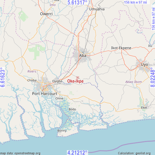
Oke-Ikpe GPS coordinates[2]
4° 54' 46.836" North, 7° 19' 9.696" East
| Map corner | latitude | longitude |
|---|---|---|
| Upper-left | 5.61317°, | 6.61623° |
| Center: | 4.91301°, | 7.31936° |
| Lower-right: | 4.21212°, | 8.02248° |
| Map W x H: | 155.8×155.8 km | = 96.8×96.8mi |
| max Lat: | 13.7543° ⇑95% North |
| Oke-Ikpe: | 4.91301° |
| min Lat: | ⇓5% South 4.31231° |
| min Long | Oke-Ikpe | max Long |
| 2.73333° | 7.31936° | 14.46552° |
| W 49.8%⇐ | ⇒50.2% E |
Elevation
Elevation of Oke-Ikpe is 23 m = 75 ft, and this is 273.5 m = 897 ft below average elevation for this country.
| Max E: |
1599 m = 5246 ft | 91.6% |
| Avg. | 296.5 m = 973 ft | |
| Oke-Ikpe | 23 m = 75 ft | |
Min E: |
2 m = 7 ft | 8.4% |
See also: Nigeria elevation on elevation.city.
Geographical zone
Oke-Ikpe is located in North Torrid zone (between Equator and Tropic of Cancer). Distance of Equator is 546.3 km =339.5 mi to South.| Distance of | km | miles | from Oke-Ikpe |
|---|---|---|---|
| North Pole | 9460.8 | 5878.7 | to North |
| Arctic Circle | 6854.9 | 4259.4 | to North |
| Tropic Cancer | 2059.6 | 1279.8 | to North |
| Equator | 546.3 | 339.5 | to South |


Nearby cities:
15 places around Oke-Ikpe: (largest is in red/bold)
• Aba
22.2 km =13.8 mi,  13°
13°
• Afam
13.7 km =8.5 mi,  183°
183°
• Akwete
5.1 km =3.2 mi,  124°
124°
• Bori
26.8 km =16.7 mi,  169°
169°
• Eberi
22 km =13.7 mi,  334°
334°
• Ikot Akpa Nkuk
27.5 km =17.1 mi,  99°
99°
• Kpor
29.2 km =18.1 mi,  187°
187°
• Nchia
25.7 km =16 mi,  238°
238°
• Ogu
25.1 km =15.6 mi,  212°
212°
• Okehi
32.1 km =19.9 mi,  321°
321°
• Okrika
32.3 km =20.1 mi,  233°
233°
• Osisioma
27.4 km =17 mi,  0°
0°
• Saakpenwa
22.7 km =14.1 mi,  195°
195°
• Urua Inyang
27.2 km =16.9 mi,  63°
63°
• Utu Etim Ekpo
33.8 km =21 mi,  72°
72°
Sources, notices
• [Note1] Compared only with cities in Nigeria existing in our database
• [Src1] Map data: © OpenStreetMap contributors (CC-BY-SA)
• [Src2] Other city data from geonames.org with taken over terms of usage.
• [Src3] Geographical zone / Annual Mean Temperature by Robert A. Rohde @ Wikipedia
