Teustepe geodata
Teustepe (Boaco) is a seat of a second-order administrative division; located in Nicaragua in America/Managua (GMT-6) time zone. With population of 4,287 people, there are 81 cities with bigger population in this country. Compared to other cities in Nicaragua, 57.5% of cities are located further ↑North; 66.5% of cities are located further ←West and 59.9% of cities have higher elevation than Teustepe. Note1


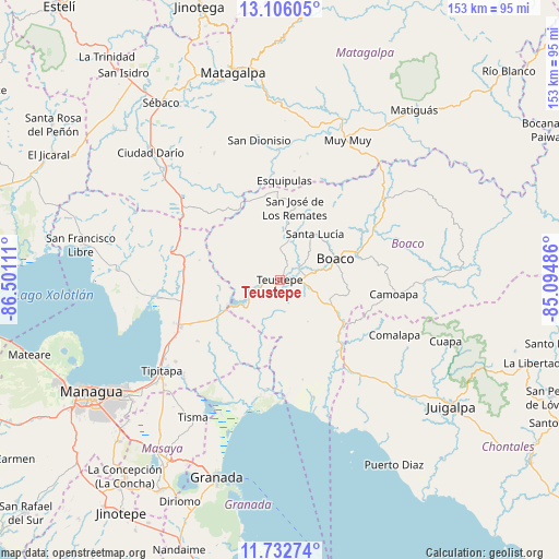
Teustepe GPS coordinates[2]
12° 25' 13.08" North, 85° 47' 52.728" West
| Map corner | latitude | longitude |
|---|---|---|
| Upper-left | 13.10605°, | -86.50111° |
| Center: | 12.4203°, | -85.79798° |
| Lower-right: | 11.73274°, | -85.09486° |
| Map W x H: | 152.7×152.7 km | = 94.9×94.9mi |
| max Lat: | 14.74189° ⇑57.5% North |
| Teustepe: | 12.4203° |
| min Lat: | ⇓42.5% South 10.94684° |
| min Long | Teustepe | max Long |
| -87.4516° | -85.79798° | -83.06145° |
| W 66.5%⇐ | ⇒33.5% E |
Elevation
Elevation of Teustepe is 155 m = 509 ft, and this is 182.2 m = 598 ft below average elevation for this country.
| Max E: |
1288 m = 4226 ft | 59.9% |
| Avg. | 337.2 m = 1106 ft | |
| Teustepe | 155 m = 509 ft | |
Min E: |
1 m = 3 ft | 40.1% |
See also: Nicaragua elevation on elevation.city.
Geographical zone
Teustepe is located in North Torrid zone (between Equator and Tropic of Cancer). Distance of this Northern Tropic circle is 1224.9 km =761.1 mi to North.| Distance of | km | miles | from Teustepe |
|---|---|---|---|
| North Pole | 8626.1 | 5360 | to North |
| Arctic Circle | 6020.2 | 3740.8 | to North |
| Tropic Cancer | 1224.9 | 761.1 | to North |
| Equator | 1381 | 858.1 | to South |


Nearby cities:
15 places around Teustepe: (largest is in red/bold)
• Boaco
16.2 km =10.1 mi,  69°
69°
• Camoapa
31.2 km =19.4 mi,  97°
97°
• Ciudad Darío
49.5 km =30.8 mi,  314°
314°
• Comalapa
34.7 km =21.6 mi,  116°
116°
• Cuapa
48.2 km =30 mi,  110°
110°
• Esquipulas
27.2 km =16.9 mi,  2°
2°
• Muy Muy
42.2 km =26.2 mi,  25°
25°
• San Dionisio
38.2 km =23.7 mi,  351°
351°
• San José de los Remates
20.1 km =12.5 mi,  11°
11°
• San Lorenzo
15 km =9.3 mi, 108°
• Santa Lucía
15.7 km =9.8 mi,  37°
37°
• Terrabona
38.9 km =24.2 mi,  332°
332°
• Tipitapa
40.9 km =25.4 mi,  232°
232°
• Tisma
44.5 km =27.7 mi,  212°
212°
• Valle San Francisco
53.8 km =33.4 mi,  281°
281°
Sources, notices
• [Note1] Compared only with cities in Nicaragua existing in our database
• [Src1] Map data: © OpenStreetMap contributors (CC-BY-SA)
• [Src2] Other city data from geonames.org with taken over terms of usage.
• [Src3] Geographical zone / Annual Mean Temperature by Robert A. Rohde @ Wikipedia
