Santa Lucía geodata
Santa Lucía (Boaco) is a seat of a second-order administrative division; located in Nicaragua in America/Managua (GMT-6) time zone. With population of 1,869 people, there are 113 cities with bigger population in this country. Compared to other cities in Nicaragua, 52.1% of cities are located further ↑North; 69.5% of cities are located further ←West and 77.2% of cities have lower elevation than Santa Lucía. Note1


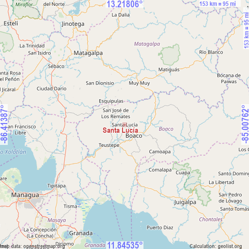
Santa Lucía GPS coordinates[2]
12° 31' 57.432" North, 85° 42' 38.664" West
| Map corner | latitude | longitude |
|---|---|---|
| Upper-left | 13.21806°, | -86.41387° |
| Center: | 12.53262°, | -85.71074° |
| Lower-right: | 11.84535°, | -85.00762° |
| Map W x H: | 152.6×152.6 km | = 94.8×94.8mi |
| max Lat: | 14.74189° ⇑52.1% North |
| Santa Lucía: | 12.53262° |
| min Lat: | ⇓47.9% South 10.94684° |
| min Long | Santa Lucía | max Long |
| -87.4516° | -85.71074° | -83.06145° |
| W 69.5%⇐ | ⇒30.5% E |
Elevation
Elevation of Santa Lucía is 553 m = 1814 ft, and this is 215.8 m = 708 ft above average elevation for this country.
| Max E: |
1288 m = 4226 ft | 22.8% |
| Santa Lucía | 553 m 1814 ft | |
| Avg. | 337.2 m = 1106 ft | |
Min E: |
1 m = 3 ft | 77.2% |
See also: Nicaragua elevation on elevation.city.
Geographical zone
Santa Lucía is located in North Torrid zone (between Equator and Tropic of Cancer). Distance of this Northern Tropic circle is 1212.4 km =753.4 mi to North.| Distance of | km | miles | from Santa Lucía |
|---|---|---|---|
| North Pole | 8613.6 | 5352.2 | to North |
| Arctic Circle | 6007.7 | 3733 | to North |
| Tropic Cancer | 1212.4 | 753.4 | to North |
| Equator | 1393.5 | 865.9 | to South |


Nearby cities:
15 places around Santa Lucía: (largest is in red/bold)
• Boaco
8.8 km =5.5 mi,  139°
139°
• Camoapa
27.1 km =16.8 mi,  127°
127°
• Ciudad Darío
50 km =31.1 mi,  296°
296°
• Comalapa
35.2 km =21.9 mi, 141°
• Cuapa
46.2 km =28.7 mi, 129°
• Esquipulas
16.9 km =10.5 mi,  330°
330°
• Matagalpa
49.1 km =30.5 mi, 332°
• Matiguás
43.3 km =26.9 mi,  38°
38°
• Muy Muy
27 km =16.8 mi,  19°
19°
• San Dionisio
29.5 km =18.3 mi, 329°
• San José de los Remates
9.1 km =5.7 mi,  322°
322°
• San Lorenzo
17.8 km =11.1 mi,  164°
164°
• San Ramón
45.6 km =28.3 mi,  342°
342°
• Terrabona
35.2 km =21.9 mi,  308°
308°
• Teustepe
15.7 km =9.8 mi,  217°
217°
Sources, notices
• [Note1] Compared only with cities in Nicaragua existing in our database
• [Src1] Map data: © OpenStreetMap contributors (CC-BY-SA)
• [Src2] Other city data from geonames.org with taken over terms of usage.
• [Src3] Geographical zone / Annual Mean Temperature by Robert A. Rohde @ Wikipedia
