Boaco geodata
Boaco is a seat of a first-order administrative division; located in Nicaragua in America/Managua (GMT-6) time zone. With population of 29,046 people, there are 21 cities with bigger population in this country. Compared to other cities in Nicaragua, 56.3% of cities are located further ↑North; 71.9% of cities are located further ←West and 58.7% of cities have lower elevation than Boaco. Note1


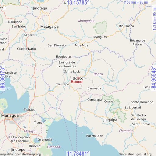
Boaco GPS coordinates[2]
12° 28' 20.064" North, 85° 39' 30.96" West
| Map corner | latitude | longitude |
|---|---|---|
| Upper-left | 13.15785°, | -86.36173° |
| Center: | 12.47224°, | -85.6586° |
| Lower-right: | 11.78481°, | -84.95548° |
| Map W x H: | 152.7×152.7 km | = 94.9×94.9mi |
| max Lat: | 14.74189° ⇑56.3% North |
| Boaco: | 12.47224° |
| min Lat: | ⇓43.7% South 10.94684° |
| min Long | Boaco | max Long |
| -87.4516° | -85.6586° | -83.06145° |
| W 71.9%⇐ | ⇒28.1% E |
Elevation
Elevation of Boaco is 380 m = 1247 ft, and this is 42.8 m = 140 ft above average elevation for this country.
| Max E: |
1288 m = 4226 ft | 41.3% |
| Boaco | 380 m 1247 ft | |
| Avg. | 337.2 m = 1106 ft | |
Min E: |
1 m = 3 ft | 58.7% |
See also: Nicaragua elevation on elevation.city.
Geographical zone
Boaco is located in North Torrid zone (between Equator and Tropic of Cancer). Distance of this Northern Tropic circle is 1219.1 km =757.5 mi to North.| Distance of | km | miles | from Boaco |
|---|---|---|---|
| North Pole | 8620.3 | 5356.4 | to North |
| Arctic Circle | 6014.4 | 3737.2 | to North |
| Tropic Cancer | 1219.1 | 757.5 | to North |
| Equator | 1386.8 | 861.7 | to South |


Nearby cities:
15 places around Boaco: (largest is in red/bold)
• Camoapa
18.6 km =11.6 mi,  121°
121°
• Comalapa
26.4 km =16.4 mi,  142°
142°
• Cuapa
37.6 km =23.4 mi,  126°
126°
• El Ayote
51.1 km =31.8 mi, 127°
• Esquipulas
25.5 km =15.8 mi,  326°
326°
• Juigalpa
51.7 km =32.1 mi, 141°
• Matiguás
45.8 km =28.5 mi,  27°
27°
• Muy Muy
32.4 km =20.1 mi,  5°
5°
• San Dionisio
38.2 km =23.7 mi, 327°
• San José de los Remates
17.9 km =11.1 mi,  321°
321°
• San Lorenzo
10.5 km =6.5 mi,  184°
184°
• San Ramón
53.8 km =33.4 mi,  338°
338°
• Santa Lucía
8.8 km =5.5 mi, 319°
• Terrabona
43.9 km =27.3 mi,  310°
310°
• Teustepe
16.2 km =10.1 mi,  249°
249°
Sources, notices
• [Note1] Compared only with cities in Nicaragua existing in our database
• [Src1] Map data: © OpenStreetMap contributors (CC-BY-SA)
• [Src2] Other city data from geonames.org with taken over terms of usage.
• [Src3] Geographical zone / Annual Mean Temperature by Robert A. Rohde @ Wikipedia
