Zuidwijk geodata
Zuidwijk (South Holland) is a section of populated place; located in Netherlands in Europe/Amsterdam (GMT+2) time zone. With population of 12,490 people, there are 244 cities with bigger population in this country. Compared to other cities in Netherlands, 59.9% of cities are located further ↑North; 89.4% of cities are located further →East and 91.3% of cities have higher elevation than Zuidwijk. Note1


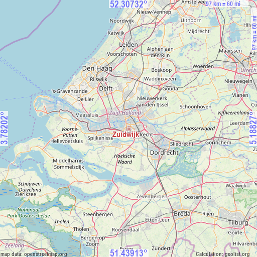
Zuidwijk GPS coordinates[2]
51° 52' 31.152" North, 4° 29' 6.504" East
| Map corner | latitude | longitude |
|---|---|---|
| Upper-left | 52.30732°, | 3.78202° |
| Center: | 51.87532°, | 4.48514° |
| Lower-right: | 51.43913°, | 5.18827° |
| Map W x H: | 96.5×96.5 km | = 60×60mi |
| max Lat: | 53.48025° ⇑59.9% North |
| Zuidwijk: | 51.87532° |
| min Lat: | ⇓40.1% South 50.76917° |
| min Long | Zuidwijk | max Long |
| 3.38611° | 4.48514° | 7.16528° |
| W 10.6%⇐ | ⇒89.4% E |
Elevation
Elevation of Zuidwijk is 0 m = 0 ft, and this is 15 m = 49 ft below average elevation for this country.
| Max E: |
203 m = 666 ft | 91.3% |
| Avg. | 15 m = 49 ft | |
| Zuidwijk | 0 m = 0 ft | |
Min E: |
-6 m = -20 ft | 8.7% |
See also: Netherlands elevation on elevation.city.
Geographical zone
Zuidwijk is located in North temperate zone (between Tropic of Cancer and the Arctic Circle). Distance of this North polar circle is 1633.2 km =1014.8 mi to North.| Distance of | km | miles | from Zuidwijk |
|---|---|---|---|
| North Pole | 4239.1 | 2634.1 | to North |
| Arctic Circle | 1633.2 | 1014.8 | to North |
| Tropic Cancer | 3162.1 | 1964.8 | to South |
| Equator | 5768 | 3584.1 | to South |


Nearby cities:
15 places around Zuidwijk: (largest is in red/bold)
• Barendrecht
4 km =2.5 mi,  121°
121°
• Bloemhof
2.6 km =1.6 mi,  21°
21°
• Carnisse
1.6 km =1 mi,  341°
341°
• Delfshaven
4 km =2.5 mi,  326°
326°
• Feijenoord
4.3 km =2.7 mi, 19°
• Groot IJsselmonde
4.5 km =2.8 mi,  79°
79°
• Heijplaat
4.8 km =3 mi,  294°
294°
• Katendrecht
2.8 km =1.7 mi,  356°
356°
• Kop van Zuid
3.4 km =2.1 mi,  2°
2°
• Lombardijen
2.5 km =1.6 mi,  93°
93°
• Pendrecht
1.2 km =0.7 mi,  249°
249°
• Rhoon
4.8 km =3 mi, 245°
• Rotterdam
5.3 km =3.3 mi, 355°
• Smitshoek
2.2 km =1.4 mi,  183°
183°
• Vreewijk
2.6 km =1.6 mi,  67°
67°
Sources, notices
• [Note1] Compared only with cities in Netherlands existing in our database
• [Src1] Map data: © OpenStreetMap contributors (CC-BY-SA)
• [Src2] Other city data from geonames.org with taken over terms of usage.
• [Src3] Geographical zone / Annual Mean Temperature by Robert A. Rohde @ Wikipedia
