Pendrecht geodata
Pendrecht (South Holland) is a section of populated place; located in Netherlands in Europe/Amsterdam (GMT+2) time zone. With population of 11,885 people, there are 254 cities with bigger population in this country. Compared to other cities in Netherlands, 60.4% of cities are located further ↑North; 90.3% of cities are located further →East and 91.3% of cities have higher elevation than Pendrecht. Note1


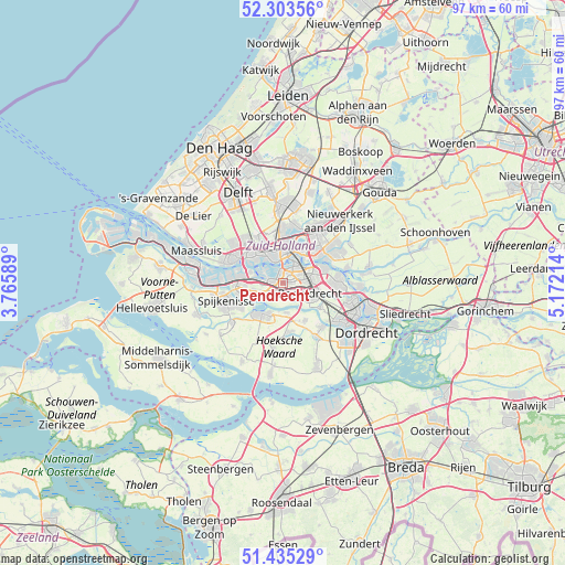
Pendrecht GPS coordinates[2]
51° 52' 17.472" North, 4° 28' 8.436" East
| Map corner | latitude | longitude |
|---|---|---|
| Upper-left | 52.30356°, | 3.76589° |
| Center: | 51.87152°, | 4.46901° |
| Lower-right: | 51.43529°, | 5.17214° |
| Map W x H: | 96.5×96.5 km | = 60×60mi |
| max Lat: | 53.48025° ⇑60.4% North |
| Pendrecht: | 51.87152° |
| min Lat: | ⇓39.6% South 50.76917° |
| min Long | Pendrecht | max Long |
| 3.38611° | 4.46901° | 7.16528° |
| W 9.7%⇐ | ⇒90.3% E |
Elevation
Elevation of Pendrecht is 0 m = 0 ft, and this is 15 m = 49 ft below average elevation for this country.
| Max E: |
203 m = 666 ft | 91.3% |
| Avg. | 15 m = 49 ft | |
| Pendrecht | 0 m = 0 ft | |
Min E: |
-6 m = -20 ft | 8.7% |
See also: Netherlands elevation on elevation.city.
Geographical zone
Pendrecht is located in North temperate zone (between Tropic of Cancer and the Arctic Circle). Distance of this North polar circle is 1633.6 km =1015.1 mi to North.| Distance of | km | miles | from Pendrecht |
|---|---|---|---|
| North Pole | 4239.5 | 2634.3 | to North |
| Arctic Circle | 1633.6 | 1015.1 | to North |
| Tropic Cancer | 3161.7 | 1964.6 | to South |
| Equator | 5767.6 | 3583.8 | to South |


Nearby cities:
15 places around Pendrecht: (largest is in red/bold)
• Barendrecht
4.8 km =3 mi,  110°
110°
• Bloemhof
3.5 km =2.2 mi,  36°
36°
• Carnisse
2.1 km =1.3 mi,  16°
16°
• Delfshaven
3.9 km =2.4 mi,  343°
343°
• Feijenoord
5.2 km =3.2 mi,  29°
29°
• Heijplaat
4.1 km =2.5 mi,  306°
306°
• Heinenoord
5.1 km =3.2 mi,  174°
174°
• Katendrecht
3.4 km =2.1 mi, 15°
• Kop van Zuid
4 km =2.5 mi, 18°
• Lombardijen
3.6 km =2.2 mi,  86°
86°
• Rhoon
3.6 km =2.2 mi,  244°
244°
• Smitshoek
2 km =1.2 mi,  151°
151°
• Spangen
5.5 km =3.4 mi, 335°
• Vreewijk
3.8 km =2.4 mi,  67°
67°
• Zuidwijk
1.2 km =0.7 mi, 69°
Sources, notices
• [Note1] Compared only with cities in Netherlands existing in our database
• [Src1] Map data: © OpenStreetMap contributors (CC-BY-SA)
• [Src2] Other city data from geonames.org with taken over terms of usage.
• [Src3] Geographical zone / Annual Mean Temperature by Robert A. Rohde @ Wikipedia
