Rhoon geodata
Rhoon (South Holland) is a populated place; located in Netherlands in Europe/Amsterdam (GMT+2) time zone. With population of 18,250 people, there are 193 cities with bigger population in this country. Compared to other cities in Netherlands, 60.8% of cities are located further ↑North; 91.6% of cities are located further →East and 83.9% of cities have higher elevation than Rhoon. Note1


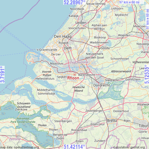
Rhoon GPS coordinates[2]
51° 51' 27" North, 4° 25' 19.992" East
| Map corner | latitude | longitude |
|---|---|---|
| Upper-left | 52.28967°, | 3.7191° |
| Center: | 51.8575°, | 4.42222° |
| Lower-right: | 51.42114°, | 5.12535° |
| Map W x H: | 96.6×96.6 km | = 60×60mi |
| max Lat: | 53.48025° ⇑60.8% North |
| Rhoon: | 51.8575° |
| min Lat: | ⇓39.2% South 50.76917° |
| min Long | Rhoon | max Long |
| 3.38611° | 4.42222° | 7.16528° |
| W 8.4%⇐ | ⇒91.6% E |
Elevation
Elevation of Rhoon is 1 m = 3 ft, and this is 14 m = 46 ft below average elevation for this country.
| Max E: |
203 m = 666 ft | 83.9% |
| Avg. | 15 m = 49 ft | |
| Rhoon | 1 m = 3 ft | |
Min E: |
-6 m = -20 ft | 16.1% |
See also: Netherlands elevation on elevation.city.
Geographical zone
Rhoon is located in North temperate zone (between Tropic of Cancer and the Arctic Circle). Distance of this North polar circle is 1635.2 km =1016.1 mi to North.| Distance of | km | miles | from Rhoon |
|---|---|---|---|
| North Pole | 4241 | 2635.2 | to North |
| Arctic Circle | 1635.2 | 1016.1 | to North |
| Tropic Cancer | 3160.1 | 1963.6 | to South |
| Equator | 5766 | 3582.8 | to South |


Nearby cities:
15 places around Rhoon: (largest is in red/bold)
• Bloemhof
6.9 km =4.3 mi,  50°
50°
• Carnisse
5.2 km =3.2 mi, 47°
• Delfshaven
5.7 km =3.5 mi,  21°
21°
• Heijplaat
4 km =2.5 mi,  358°
358°
• Heinenoord
5.1 km =3.2 mi,  133°
133°
• Katendrecht
6.3 km =3.9 mi,  40°
40°
• Kop van Zuid
7 km =4.3 mi, 39°
• Lombardijen
7.1 km =4.4 mi,  75°
75°
• Oud-Beijerland
3.8 km =2.4 mi,  190°
190°
• Pendrecht
3.6 km =2.2 mi,  64°
64°
• Pernis
4.1 km =2.5 mi,  326°
326°
• Smitshoek
4.2 km =2.6 mi,  92°
92°
• Spangen
6.7 km =4.2 mi,  7°
7°
• Spijkenisse
6.5 km =4 mi,  257°
257°
• Zuidwijk
4.8 km =3 mi,  65°
65°
Sources, notices
• [Note1] Compared only with cities in Netherlands existing in our database
• [Src1] Map data: © OpenStreetMap contributors (CC-BY-SA)
• [Src2] Other city data from geonames.org with taken over terms of usage.
• [Src3] Geographical zone / Annual Mean Temperature by Robert A. Rohde @ Wikipedia
