Benthuizen geodata
Benthuizen (South Holland) is a populated place; located in Netherlands in Europe/Amsterdam (GMT+2) time zone. With population of 18,959 people, there are 186 cities with bigger population in this country. Compared to other cities in Netherlands, 53.3% of cities are located further ↓South; 87.9% of cities are located further →East and 98.2% of cities have higher elevation than Benthuizen. Note1


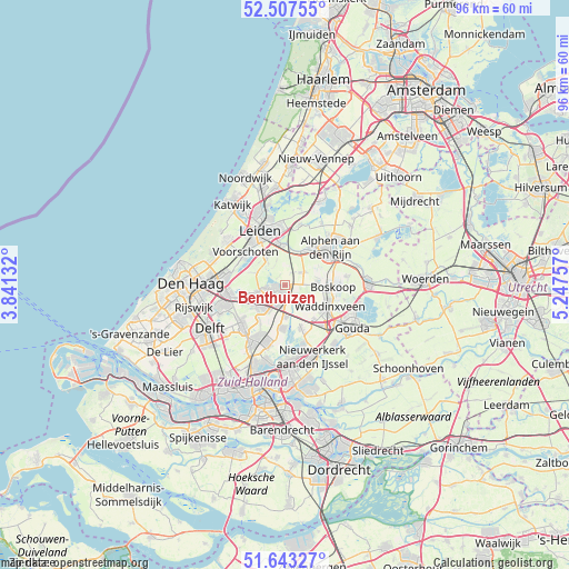
Benthuizen GPS coordinates[2]
52° 4' 39" North, 4° 32' 39.984" East
| Map corner | latitude | longitude |
|---|---|---|
| Upper-left | 52.50755°, | 3.84132° |
| Center: | 52.0775°, | 4.54444° |
| Lower-right: | 51.64327°, | 5.24757° |
| Map W x H: | 96.1×96.1 km | = 59.7×59.7mi |
| max Lat: | 53.48025° ⇑46.7% North |
| Benthuizen: | 52.0775° |
| min Lat: | ⇓53.3% South 50.76917° |
| min Long | Benthuizen | max Long |
| 3.38611° | 4.54444° | 7.16528° |
| W 12.1%⇐ | ⇒87.9% E |
Elevation
Elevation of Benthuizen is -2 m = -7 ft, and this is 17 m = 56 ft below average elevation for this country.
| Max E: |
203 m = 666 ft | 98.2% |
| Avg. | 15 m = 49 ft | |
| Benthuizen | -2 m = -7 ft | |
Min E: |
-6 m = -20 ft | 1.8% |
See also: Netherlands elevation on elevation.city.
Geographical zone
Benthuizen is located in North temperate zone (between Tropic of Cancer and the Arctic Circle). Distance of this North polar circle is 1610.7 km =1000.8 mi to North.| Distance of | km | miles | from Benthuizen |
|---|---|---|---|
| North Pole | 4216.6 | 2620.1 | to North |
| Arctic Circle | 1610.7 | 1000.8 | to North |
| Tropic Cancer | 3184.6 | 1978.8 | to South |
| Equator | 5790.5 | 3598 | to South |


Nearby cities:
15 places around Benthuizen: (largest is in red/bold)
• Bleiswijk
7.5 km =4.7 mi,  186°
186°
• Boskoop
7.6 km =4.7 mi,  92°
92°
• Driemanspolder
5 km =3.1 mi,  234°
234°
• Groenswaard
7.5 km =4.7 mi,  112°
112°
• Noordeinde
8 km =5 mi,  211°
211°
• Oranjewijk
8.1 km =5 mi, 112°
• Palenstein
3.4 km =2.1 mi, 225°
• Vlietwijk
7.9 km =4.9 mi,  311°
311°
• Vondelwijk
7.8 km =4.8 mi, 108°
• Voorschoten
8.6 km =5.3 mi, 310°
• Voorweg
5.4 km =3.4 mi,  76°
76°
• Waddinxveen
8.2 km =5.1 mi,  116°
116°
• Zoetermeer
4.2 km =2.6 mi,  237°
237°
• Zoeterwoude-Dorp
5.8 km =3.6 mi,  324°
324°
• Zuidbuurt
4.4 km =2.7 mi, 321°
Sources, notices
• [Note1] Compared only with cities in Netherlands existing in our database
• [Src1] Map data: © OpenStreetMap contributors (CC-BY-SA)
• [Src2] Other city data from geonames.org with taken over terms of usage.
• [Src3] Geographical zone / Annual Mean Temperature by Robert A. Rohde @ Wikipedia
