Wilp geodata
Wilp (Gelderland) is a populated place; located in Netherlands in Europe/Amsterdam (GMT+2) time zone. With population of 970 people, there are 1423 cities with bigger population in this country. Compared to other cities in Netherlands, 62% of cities are located further ↓South; 81.7% of cities are located further ←West and 52.4% of cities have lower elevation than Wilp. Note1


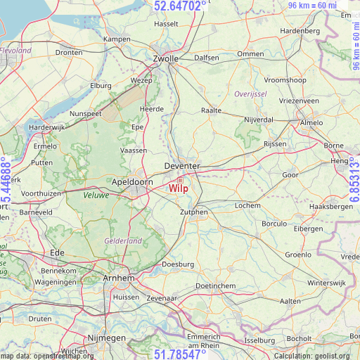
Wilp GPS coordinates[2]
52° 13' 5.988" North, 6° 9' 0" East
| Map corner | latitude | longitude |
|---|---|---|
| Upper-left | 52.64702°, | 5.44688° |
| Center: | 52.21833°, | 6.15° |
| Lower-right: | 51.78547°, | 6.85313° |
| Map W x H: | 95.8×95.8 km | = 59.5×59.5mi |
| max Lat: | 53.48025° ⇑38% North |
| Wilp: | 52.21833° |
| min Lat: | ⇓62% South 50.76917° |
| min Long | Wilp | max Long |
| 3.38611° | 6.15° | 7.16528° |
| W 81.7%⇐ | ⇒18.3% E |
Elevation
Elevation of Wilp is 7 m = 23 ft, and this is 8 m = 26 ft below average elevation for this country.
| Max E: |
203 m = 666 ft | 47.6% |
| Avg. | 15 m = 49 ft | |
| Wilp | 7 m = 23 ft | |
Min E: |
-6 m = -20 ft | 52.4% |
See also: Netherlands elevation on elevation.city.
Geographical zone
Wilp is located in North temperate zone (between Tropic of Cancer and the Arctic Circle). Distance of this North polar circle is 1595 km =991.1 mi to North.| Distance of | km | miles | from Wilp |
|---|---|---|---|
| North Pole | 4200.9 | 2610.3 | to North |
| Arctic Circle | 1595 | 991.1 | to North |
| Tropic Cancer | 3200.2 | 1988.5 | to South |
| Equator | 5806.1 | 3607.7 | to South |


Nearby cities:
15 places around Wilp: (largest is in red/bold)
• Borgele
6.4 km =4 mi,  359°
359°
• De Hoven
3.4 km =2.1 mi,  352°
352°
• Deventer
4.2 km =2.6 mi,  13°
13°
• Eefde
7.7 km =4.8 mi,  138°
138°
• Empe
7 km =4.3 mi,  186°
186°
• Epse
3.5 km =2.2 mi,  77°
77°
• Gorssel
4 km =2.5 mi,  117°
117°
• Het Oostrik
5.7 km =3.5 mi,  52°
52°
• Klarenbeek
8.2 km =5.1 mi,  226°
226°
• Schalkhaar
6.3 km =3.9 mi,  28°
28°
• Terwolde
8 km =5 mi,  334°
334°
• Twello
3.8 km =2.4 mi,  302°
302°
• Voorst
5.4 km =3.4 mi, 186°
• Woudhuis
9.5 km =5.9 mi,  266°
266°
• Zutphen
9.6 km =6 mi,  158°
158°
Sources, notices
• [Note1] Compared only with cities in Netherlands existing in our database
• [Src1] Map data: © OpenStreetMap contributors (CC-BY-SA)
• [Src2] Other city data from geonames.org with taken over terms of usage.
• [Src3] Geographical zone / Annual Mean Temperature by Robert A. Rohde @ Wikipedia
