Empe geodata
Empe (Gelderland) is a populated place; located in Netherlands in Europe/Amsterdam (GMT+2) time zone. With population of 708 people, there are 1621 cities with bigger population in this country. Compared to other cities in Netherlands, 57.3% of cities are located further ↓South; 81.1% of cities are located further ←West and 50.6% of cities have higher elevation than Empe. Note1


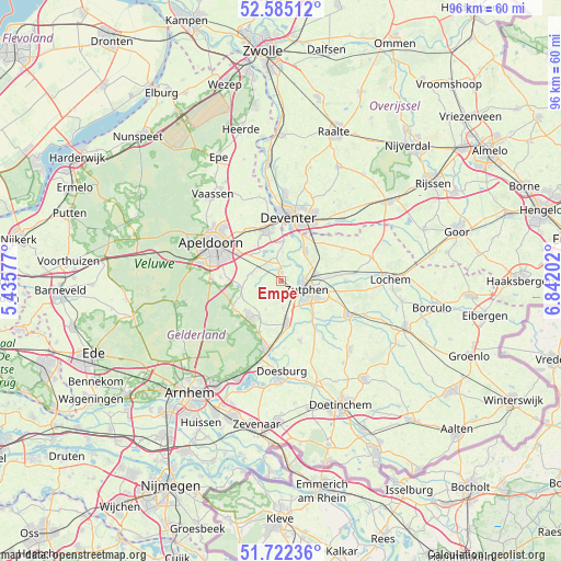
Empe GPS coordinates[2]
52° 9' 20.988" North, 6° 8' 20.004" East
| Map corner | latitude | longitude |
|---|---|---|
| Upper-left | 52.58512°, | 5.43577° |
| Center: | 52.15583°, | 6.13889° |
| Lower-right: | 51.72236°, | 6.84202° |
| Map W x H: | 95.9×95.9 km | = 59.6×59.6mi |
| max Lat: | 53.48025° ⇑42.7% North |
| Empe: | 52.15583° |
| min Lat: | ⇓57.3% South 50.76917° |
| min Long | Empe | max Long |
| 3.38611° | 6.13889° | 7.16528° |
| W 81.1%⇐ | ⇒18.9% E |
Elevation
Elevation of Empe is 6 m = 20 ft, and this is 9 m = 30 ft below average elevation for this country.
| Max E: |
203 m = 666 ft | 50.6% |
| Avg. | 15 m = 49 ft | |
| Empe | 6 m = 20 ft | |
Min E: |
-6 m = -20 ft | 49.4% |
See also: Netherlands elevation on elevation.city.
Geographical zone
Empe is located in North temperate zone (between Tropic of Cancer and the Arctic Circle). Distance of this North polar circle is 1602 km =995.4 mi to North.| Distance of | km | miles | from Empe |
|---|---|---|---|
| North Pole | 4207.9 | 2614.7 | to North |
| Arctic Circle | 1602 | 995.4 | to North |
| Tropic Cancer | 3193.3 | 1984.2 | to South |
| Equator | 5799.2 | 3603.5 | to South |


Nearby cities:
15 places around Empe: (largest is in red/bold)
• Brummen
7.4 km =4.6 mi,  171°
171°
• Eefde
6 km =3.7 mi,  78°
78°
• Eerbeek
7.9 km =4.9 mi,  224°
224°
• Epse
8.7 km =5.4 mi,  28°
28°
• Gorssel
6.6 km =4.1 mi,  39°
39°
• Klarenbeek
5.4 km =3.4 mi,  283°
283°
• Laag-Soeren
9.1 km =5.7 mi,  208°
208°
• Leesten
7.1 km =4.4 mi,  116°
116°
• Oosterhuizen
9.1 km =5.7 mi,  270°
270°
• Ooyerhoek
6.5 km =4 mi, 117°
• Voorst
1.6 km =1 mi,  6°
6°
• Warken
9 km =5.6 mi,  101°
101°
• Warnsveld
6.6 km =4.1 mi,  108°
108°
• Wilp
7 km =4.3 mi, 6°
• Zutphen
4.7 km =2.9 mi, 114°
Sources, notices
• [Note1] Compared only with cities in Netherlands existing in our database
• [Src1] Map data: © OpenStreetMap contributors (CC-BY-SA)
• [Src2] Other city data from geonames.org with taken over terms of usage.
• [Src3] Geographical zone / Annual Mean Temperature by Robert A. Rohde @ Wikipedia
