Wilhelminadorp geodata
Wilhelminadorp (Zeeland) is a populated place; located in Netherlands in Europe/Amsterdam (GMT+2) time zone. With population of 665 people, there are 1661 cities with bigger population in this country. Compared to other cities in Netherlands, 78.6% of cities are located further ↑North; 97.3% of cities are located further →East and 83.9% of cities have higher elevation than Wilhelminadorp. Note1


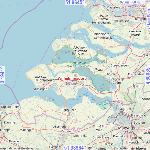
Wilhelminadorp GPS coordinates[2]
51° 31' 45.012" North, 3° 53' 49.992" East
| Map corner | latitude | longitude |
|---|---|---|
| Upper-left | 51.9645°, | 3.1941° |
| Center: | 51.52917°, | 3.89722° |
| Lower-right: | 51.08964°, | 4.60035° |
| Map W x H: | 97.3×97.3 km | = 60.5×60.5mi |
| max Lat: | 53.48025° ⇑78.6% North |
| Wilhelminadorp: | 51.52917° |
| min Lat: | ⇓21.4% South 50.76917° |
| min Long | Wilhelminadorp | max Long |
| 3.38611° | 3.89722° | 7.16528° |
| W 2.7%⇐ | ⇒97.3% E |
Elevation
Elevation of Wilhelminadorp is 1 m = 3 ft, and this is 14 m = 46 ft below average elevation for this country.
| Max E: |
203 m = 666 ft | 83.9% |
| Avg. | 15 m = 49 ft | |
| Wilhelminadorp | 1 m = 3 ft | |
Min E: |
-6 m = -20 ft | 16.1% |
See also: Netherlands elevation on elevation.city.
Geographical zone
Wilhelminadorp is located in North temperate zone (between Tropic of Cancer and the Arctic Circle). Distance of this North polar circle is 1671.7 km =1038.7 mi to North.| Distance of | km | miles | from Wilhelminadorp |
|---|---|---|---|
| North Pole | 4277.6 | 2658 | to North |
| Arctic Circle | 1671.7 | 1038.7 | to North |
| Tropic Cancer | 3123.6 | 1940.9 | to South |
| Equator | 5729.5 | 3560.1 | to South |


Nearby cities:
15 places around Wilhelminadorp: (largest is in red/bold)
• Colijnsplaat
8.5 km =5.3 mi,  336°
336°
• Driewegen
14 km =8.7 mi,  207°
207°
• Goes
2.8 km =1.7 mi,  191°
191°
• Kamperland
14.2 km =8.8 mi,  289°
289°
• Kapelle
6.4 km =4 mi,  138°
138°
• Kloetinge
3.6 km =2.2 mi,  159°
159°
• Malta
13.7 km =8.5 mi,  10°
10°
• Nieuwerkerk
15.3 km =9.5 mi,  28°
28°
• Scherpenisse
14.5 km =9 mi,  82°
82°
• Stavenisse
10.3 km =6.4 mi,  50°
50°
• Wemeldinge
7 km =4.3 mi,  99°
99°
• Wissenkerke
12.1 km =7.5 mi,  300°
300°
• Wolphaartsdijk
5.4 km =3.4 mi,  272°
272°
• Yerseke
11.3 km =7 mi,  111°
111°
• Zierikzee
13.5 km =8.4 mi, 6°
Sources, notices
• [Note1] Compared only with cities in Netherlands existing in our database
• [Src1] Map data: © OpenStreetMap contributors (CC-BY-SA)
• [Src2] Other city data from geonames.org with taken over terms of usage.
• [Src3] Geographical zone / Annual Mean Temperature by Robert A. Rohde @ Wikipedia
