Dinteloord geodata
Dinteloord (North Brabant) is a populated place; located in Netherlands in Europe/Amsterdam (GMT+2) time zone. With population of 5,105 people, there are 475 cities with bigger population in this country. Compared to other cities in Netherlands, 72.3% of cities are located further ↑North; 92.6% of cities are located further →East and 96.1% of cities have higher elevation than Dinteloord. Note1


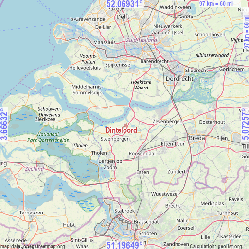
Dinteloord GPS coordinates[2]
51° 38' 6" North, 4° 22' 9.984" East
| Map corner | latitude | longitude |
|---|---|---|
| Upper-left | 52.06931°, | 3.66632° |
| Center: | 51.635°, | 4.36944° |
| Lower-right: | 51.19649°, | 5.07257° |
| Map W x H: | 97×97 km | = 60.3×60.3mi |
| max Lat: | 53.48025° ⇑72.3% North |
| Dinteloord: | 51.635° |
| min Lat: | ⇓27.7% South 50.76917° |
| min Long | Dinteloord | max Long |
| 3.38611° | 4.36944° | 7.16528° |
| W 7.4%⇐ | ⇒92.6% E |
Elevation
Elevation of Dinteloord is -1 m = -3 ft, and this is 16 m = 52 ft below average elevation for this country.
| Max E: |
203 m = 666 ft | 96.1% |
| Avg. | 15 m = 49 ft | |
| Dinteloord | -1 m = -3 ft | |
Min E: |
-6 m = -20 ft | 3.9% |
See also: Netherlands elevation on elevation.city.
Geographical zone
Dinteloord is located in North temperate zone (between Tropic of Cancer and the Arctic Circle). Distance of this North polar circle is 1659.9 km =1031.4 mi to North.| Distance of | km | miles | from Dinteloord |
|---|---|---|---|
| North Pole | 4265.8 | 2650.6 | to North |
| Arctic Circle | 1659.9 | 1031.4 | to North |
| Tropic Cancer | 3135.4 | 1948.2 | to South |
| Equator | 5741.3 | 3567.5 | to South |


Nearby cities:
15 places around Dinteloord: (largest is in red/bold)
• Fijnaart
6.9 km =4.3 mi,  87°
87°
• Heijningen
3.5 km =2.2 mi,  49°
49°
• Helwijk
6.3 km =3.9 mi,  43°
43°
• Kruisland
7.8 km =4.8 mi,  159°
159°
• Lepelstraat
11.6 km =7.2 mi,  213°
213°
• Nieuw-Vossemeer
11.6 km =7.2 mi,  244°
244°
• Noordhoek
11.2 km =7 mi, 85°
• Numansdorp
11.7 km =7.3 mi,  23°
23°
• Oud Gastel
8.2 km =5.1 mi,  130°
130°
• Stampersgat
5.7 km =3.5 mi,  114°
114°
• Standdaarbuiten
10.3 km =6.4 mi,  103°
103°
• Steenbergen
6.6 km =4.1 mi, 211°
• Stoof
8.5 km =5.3 mi,  118°
118°
• Welberg
7 km =4.3 mi,  202°
202°
• Willemstad
7.9 km =4.9 mi, 37°
Sources, notices
• [Note1] Compared only with cities in Netherlands existing in our database
• [Src1] Map data: © OpenStreetMap contributors (CC-BY-SA)
• [Src2] Other city data from geonames.org with taken over terms of usage.
• [Src3] Geographical zone / Annual Mean Temperature by Robert A. Rohde @ Wikipedia
