Ophemert geodata
Ophemert (Gelderland) is a populated place; located in Netherlands in Europe/Amsterdam (GMT+2) time zone. With population of 1,425 people, there are 1167 cities with bigger population in this country. Compared to other cities in Netherlands, 61.5% of cities are located further ↑North; 61.3% of cities are located further →East and 54.1% of cities have higher elevation than Ophemert. Note1


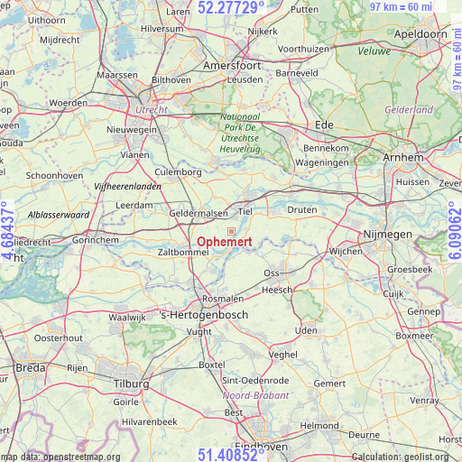
Ophemert GPS coordinates[2]
51° 50' 42" North, 5° 23' 15" East
| Map corner | latitude | longitude |
|---|---|---|
| Upper-left | 52.27729°, | 4.68437° |
| Center: | 51.845°, | 5.3875° |
| Lower-right: | 51.40852°, | 6.09062° |
| Map W x H: | 96.6×96.6 km | = 60×60mi |
| max Lat: | 53.48025° ⇑61.5% North |
| Ophemert: | 51.845° |
| min Lat: | ⇓38.5% South 50.76917° |
| min Long | Ophemert | max Long |
| 3.38611° | 5.3875° | 7.16528° |
| W 38.7%⇐ | ⇒61.3% E |
Elevation
Elevation of Ophemert is 5 m = 16 ft, and this is 10 m = 33 ft below average elevation for this country.
| Max E: |
203 m = 666 ft | 54.1% |
| Avg. | 15 m = 49 ft | |
| Ophemert | 5 m = 16 ft | |
Min E: |
-6 m = -20 ft | 45.9% |
See also: Netherlands elevation on elevation.city.
Geographical zone
Ophemert is located in North temperate zone (between Tropic of Cancer and the Arctic Circle). Distance of this North polar circle is 1636.6 km =1016.9 mi to North.| Distance of | km | miles | from Ophemert |
|---|---|---|---|
| North Pole | 4242.4 | 2636.1 | to North |
| Arctic Circle | 1636.6 | 1016.9 | to North |
| Tropic Cancer | 3158.7 | 1962.7 | to South |
| Equator | 5764.6 | 3582 | to South |


Nearby cities:
15 places around Ophemert: (largest is in red/bold)
• Alem
7.2 km =4.5 mi,  205°
205°
• Drumpt
6 km =3.7 mi,  15°
15°
• Geldermalsen
7.9 km =4.9 mi,  300°
300°
• Heerewaarden
3.1 km =1.9 mi,  172°
172°
• Hurwenen
6.2 km =3.9 mi,  232°
232°
• Lith
5.6 km =3.5 mi,  140°
140°
• Lithoijen
7.1 km =4.4 mi,  131°
131°
• Maren-Kessel
5.5 km =3.4 mi,  176°
176°
• Meteren
7.5 km =4.7 mi,  287°
287°
• Opijnen
6.4 km =4 mi,  253°
253°
• Rossum
6.2 km =3.9 mi,  217°
217°
• Tiel
5.4 km =3.4 mi,  31°
31°
• Varik
2.7 km =1.7 mi, 205°
• Wadenoijen
3.4 km =2.1 mi,  342°
342°
• Zoelen
7.6 km =4.7 mi,  7°
7°
Sources, notices
• [Note1] Compared only with cities in Netherlands existing in our database
• [Src1] Map data: © OpenStreetMap contributors (CC-BY-SA)
• [Src2] Other city data from geonames.org with taken over terms of usage.
• [Src3] Geographical zone / Annual Mean Temperature by Robert A. Rohde @ Wikipedia
