Tiel geodata
Tiel (Gelderland) is a populated place; located in Netherlands in Europe/Amsterdam (GMT+2) time zone. With population of 40,702 people, there are 78 cities with bigger population in this country. Compared to other cities in Netherlands, 58.8% of cities are located further ↑North; 59.4% of cities are located further →East and 55.1% of cities have lower elevation than Tiel. Note1


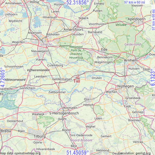
Tiel GPS coordinates[2]
51° 53' 12.012" North, 5° 25' 45.012" East
| Map corner | latitude | longitude |
|---|---|---|
| Upper-left | 52.31856°, | 4.72605° |
| Center: | 51.88667°, | 5.42917° |
| Lower-right: | 51.45059°, | 6.1323° |
| Map W x H: | 96.5×96.5 km | = 60×60mi |
| max Lat: | 53.48025° ⇑58.8% North |
| Tiel: | 51.88667° |
| min Lat: | ⇓41.2% South 50.76917° |
| min Long | Tiel | max Long |
| 3.38611° | 5.42917° | 7.16528° |
| W 40.6%⇐ | ⇒59.4% E |
Elevation
Elevation of Tiel is 8 m = 26 ft, and this is 7 m = 23 ft below average elevation for this country.
| Max E: |
203 m = 666 ft | 44.9% |
| Avg. | 15 m = 49 ft | |
| Tiel | 8 m = 26 ft | |
Min E: |
-6 m = -20 ft | 55.1% |
See also: Tiel elevation on elevation.city.
Geographical zone
Tiel is located in North temperate zone (between Tropic of Cancer and the Arctic Circle). Distance of this North polar circle is 1631.9 km =1014 mi to North.| Distance of | km | miles | from Tiel |
|---|---|---|---|
| North Pole | 4237.8 | 2633.2 | to North |
| Arctic Circle | 1631.9 | 1014 | to North |
| Tropic Cancer | 3163.3 | 1965.6 | to South |
| Equator | 5769.3 | 3584.9 | to South |


Nearby cities:
15 places around Tiel: (largest is in red/bold)
• Buurmalsen
9.3 km =5.8 mi,  273°
273°
• Drumpt
1.7 km =1.1 mi,  311°
311°
• Echteld
5.3 km =3.3 mi,  60°
60°
• Eck en Wiel
9.4 km =5.8 mi,  11°
11°
• Heerewaarden
8.1 km =5 mi,  197°
197°
• IJzendoorn
7.5 km =4.7 mi,  73°
73°
• Ingen
8.9 km =5.5 mi,  25°
25°
• Lienden
9.2 km =5.7 mi,  41°
41°
• Lith
9 km =5.6 mi,  175°
175°
• Maurik
8.3 km =5.2 mi,  356°
356°
• Oijen
8.6 km =5.3 mi,  143°
143°
• Ophemert
5.4 km =3.4 mi,  211°
211°
• Varik
8.1 km =5 mi, 209°
• Wadenoijen
4.1 km =2.5 mi,  250°
250°
• Zoelen
3.4 km =2.1 mi,  327°
327°
Sources, notices
• [Note1] Compared only with cities in Netherlands existing in our database
• [Src1] Map data: © OpenStreetMap contributors (CC-BY-SA)
• [Src2] Other city data from geonames.org with taken over terms of usage.
• [Src3] Geographical zone / Annual Mean Temperature by Robert A. Rohde @ Wikipedia
