Waardenburg geodata
Waardenburg (Gelderland) is a populated place; located in Netherlands in Europe/Amsterdam (GMT+2) time zone. With population of 1,740 people, there are 1034 cities with bigger population in this country. Compared to other cities in Netherlands, 62.3% of cities are located further ↑North; 64.9% of cities are located further →East and 54.1% of cities have higher elevation than Waardenburg. Note1


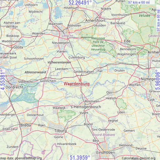
Waardenburg GPS coordinates[2]
51° 49' 57" North, 5° 15' 24.984" East
| Map corner | latitude | longitude |
|---|---|---|
| Upper-left | 52.26491°, | 4.55381° |
| Center: | 51.8325°, | 5.25694° |
| Lower-right: | 51.3959°, | 5.96006° |
| Map W x H: | 96.6×96.6 km | = 60×60mi |
| max Lat: | 53.48025° ⇑62.3% North |
| Waardenburg: | 51.8325° |
| min Lat: | ⇓37.7% South 50.76917° |
| min Long | Waardenburg | max Long |
| 3.38611° | 5.25694° | 7.16528° |
| W 35.1%⇐ | ⇒64.9% E |
Elevation
Elevation of Waardenburg is 5 m = 16 ft, and this is 10 m = 33 ft below average elevation for this country.
| Max E: |
203 m = 666 ft | 54.1% |
| Avg. | 15 m = 49 ft | |
| Waardenburg | 5 m = 16 ft | |
Min E: |
-6 m = -20 ft | 45.9% |
See also: Netherlands elevation on elevation.city.
Geographical zone
Waardenburg is located in North temperate zone (between Tropic of Cancer and the Arctic Circle). Distance of this North polar circle is 1637.9 km =1017.7 mi to North.| Distance of | km | miles | from Waardenburg |
|---|---|---|---|
| North Pole | 4243.8 | 2637 | to North |
| Arctic Circle | 1637.9 | 1017.7 | to North |
| Tropic Cancer | 3157.3 | 1961.9 | to South |
| Equator | 5763.2 | 3581.1 | to South |


Nearby cities:
15 places around Waardenburg: (largest is in red/bold)
• Bruchem
5.3 km =3.3 mi,  195°
195°
• Buurmalsen
7.1 km =4.4 mi,  21°
21°
• Deil
5.8 km =3.6 mi,  350°
350°
• Gameren
5.1 km =3.2 mi,  225°
225°
• Geldermalsen
5.8 km =3.6 mi, 22°
• Geldermalsen-West
5.5 km =3.4 mi, 16°
• Haaften
3.7 km =2.3 mi,  239°
239°
• Hellouw
5.6 km =3.5 mi,  263°
263°
• Hurwenen
4.8 km =3 mi,  120°
120°
• Meteren
4 km =2.5 mi,  26°
26°
• Nieuwaal
6 km =3.7 mi,  245°
245°
• Opijnen
2.9 km =1.8 mi,  97°
97°
• Rossum
6.3 km =3.9 mi, 123°
• Tricht
6.5 km =4 mi,  6°
6°
• Zaltbommel
2.6 km =1.6 mi, 198°
Sources, notices
• [Note1] Compared only with cities in Netherlands existing in our database
• [Src1] Map data: © OpenStreetMap contributors (CC-BY-SA)
• [Src2] Other city data from geonames.org with taken over terms of usage.
• [Src3] Geographical zone / Annual Mean Temperature by Robert A. Rohde @ Wikipedia
