Haaften geodata
Haaften (Gelderland) is a populated place; located in Netherlands in Europe/Amsterdam (GMT+2) time zone. With population of 2,370 people, there are 873 cities with bigger population in this country. Compared to other cities in Netherlands, 63.6% of cities are located further ↑North; 66.2% of cities are located further →East and 58.8% of cities have higher elevation than Haaften. Note1


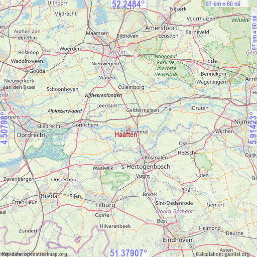
Haaften GPS coordinates[2]
51° 48' 56.988" North, 5° 12' 39.996" East
| Map corner | latitude | longitude |
|---|---|---|
| Upper-left | 52.2484°, | 4.50798° |
| Center: | 51.81583°, | 5.21111° |
| Lower-right: | 51.37907°, | 5.91423° |
| Map W x H: | 96.7×96.7 km | = 60.1×60.1mi |
| max Lat: | 53.48025° ⇑63.6% North |
| Haaften: | 51.81583° |
| min Lat: | ⇓36.4% South 50.76917° |
| min Long | Haaften | max Long |
| 3.38611° | 5.21111° | 7.16528° |
| W 33.8%⇐ | ⇒66.2% E |
Elevation
Elevation of Haaften is 4 m = 13 ft, and this is 11 m = 36 ft below average elevation for this country.
| Max E: |
203 m = 666 ft | 58.8% |
| Avg. | 15 m = 49 ft | |
| Haaften | 4 m = 13 ft | |
Min E: |
-6 m = -20 ft | 41.2% |
See also: Netherlands elevation on elevation.city.
Geographical zone
Haaften is located in North temperate zone (between Tropic of Cancer and the Arctic Circle). Distance of this North polar circle is 1639.8 km =1018.9 mi to North.| Distance of | km | miles | from Haaften |
|---|---|---|---|
| North Pole | 4245.7 | 2638.2 | to North |
| Arctic Circle | 1639.8 | 1018.9 | to North |
| Tropic Cancer | 3155.5 | 1960.7 | to South |
| Equator | 5761.4 | 3580 | to South |


Nearby cities:
15 places around Haaften: (largest is in red/bold)
• Aalst
6.8 km =4.2 mi,  237°
237°
• Ammerzoden
7.4 km =4.6 mi,  174°
174°
• Bruchem
3.7 km =2.3 mi,  152°
152°
• Gameren
1.7 km =1.1 mi,  195°
195°
• Hellouw
2.7 km =1.7 mi,  296°
296°
• Herwijnen
5.8 km =3.6 mi,  282°
282°
• Hurwenen
7.3 km =4.5 mi,  94°
94°
• Meteren
7.4 km =4.6 mi,  42°
42°
• Nederhemert
6.4 km =4 mi,  207°
207°
• Nederhemert-Noord
6.4 km =4 mi, 204°
• Nieuwaal
2.4 km =1.5 mi,  254°
254°
• Opijnen
6.2 km =3.9 mi,  76°
76°
• Waardenburg
3.7 km =2.3 mi,  59°
59°
• Zaltbommel
2.4 km =1.5 mi,  105°
105°
• Zuilichem
5.2 km =3.2 mi,  261°
261°
Sources, notices
• [Note1] Compared only with cities in Netherlands existing in our database
• [Src1] Map data: © OpenStreetMap contributors (CC-BY-SA)
• [Src2] Other city data from geonames.org with taken over terms of usage.
• [Src3] Geographical zone / Annual Mean Temperature by Robert A. Rohde @ Wikipedia
